Route Editor

| Guide | ♦ | 148 Triplogs | 0 Topics |
details | drive | no permit | forecast | map |
stats |
photos | triplogs | topics | location |
| 255 | 148 | 0 |
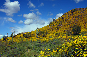
the whole thing is silly by ck_1  In 2008, the Superstition Area Land Trust (SALT) partnered with the City of Apache Junction to restore the scar on the face of Silly Mountain.
Outdated 2002 Description: You've seen it while driving by at 65+ miles per hour; as you approach mile marker 200 on the US 60, just after the freeway ends. First, you notice the wide road like track heading straight up the western side of the mountain. You may have spotted a few hikers making their way up. You might even have thought... "Now that's silly. It's only about a 1/2 mile to the top." It is silly. It's Silly Mountain! Now, I must say, I feel sort of, well, silly to post a report on such a short hike. In my defense, I believe this is a popular hike for people. Any time I drive by, I see cars in the parking area. So, it deserves a place at HAZ! Now, let's look at the trail. It's wide. It's really wide. It's like a road. It used to be a road, and people who enjoy driving their trucks up big hills drove their trucks up Silly Mountain. Much to the distress of people who like to drive trucks up big hills, Silly Mountain is closed to trucks. But you can hike it! Just leave your truck in the parking area. If you need help following the trail, you need to go back home and watch T.V. You should also consider not procreating. This is a no brainer. Walk up the hill. About 2/3rds of the way to the saddle, there are rather large rocks spread across the track. This is a nice spot to catch your breath, as the hill is rather steep. If you'd like, you can forgo the wide trail continuing up and head down the spur trail to the north. This short trail leads to the northern end of the mountain, where you can return to the parking area via a second really wide track. But don't do that. Keep going up. The steepness increases until you reach the saddle, which took me all of 7 minutes. The view is rather nice, except you can see where they are putting in a new golf course between Silly Mountain and the Sups. This is important; Arizona needs more golf courses because I don't think every single golfer has their own course yet! Back to the trail. From the saddle, you can skip on over to the southern summit, at an elevation of 2122ft. After doing so, return to the saddle and continue up the wide trail to the true summit of Silly Mountain. This is equally as steep and is also eroded. Just below the summit, the wide trail becomes a single-track that you can follow around the eastern side of the mountain and then up to the summit at 2139ft. Descend the same way you ascended. Please don't attempt to go off-trail and descend the northwestern side of Silly Mountain, like Buffet and I did. This was a less than stellar decision on my part. The Sups' views are impressive, and on this rather clear day, we could see Camelback and the Papago Buttes. I say we, but I mean me. I don't know how far my dog can see, and I'm pretty sure she wasn't looking at Camelback but rather the Doberman coming up the trail. Exploring the whole area will take less than 45 minutes, even if you walk slowly and take your time. The elevation gain is significant because the trail itself can't be more than a 1/2 mile to the summit. This hike would be a great trail run workout! Check out the Triplogs. Leave No Trace and +Add a Triplog after your hike to support this local community. | |||||||||||||||||||||||||||||||||||||||||||||||||||||||||||||||||||||||||||||||||||||||||||||||||||||||||||||||||||||||||||||||||||||||||||||||||||||||||