username
X
password
register
for free!
help
  🔥

Campaign Crystalline / Murphy Pile, AZ

Guide 2 Triplogs  0 Topics
  3 of 5  
Fav
Wish
0
details
drive
no permit
forecast
🔥
route  
stats
photos
triplogs
topics
location
2 2 0
Warning! Technical climbing skills required. Risks include serious injury to death.  Risks are not eliminated by skill.
Historical Weather
Trailhead Forecast
Radar Map
Expand Map
Preferred Dec, Jan, Feb, Mar → 7 AM
Seasons   Autumn to Spring
Sun  6:01am - 6:45pm
Official Route
 
0 Alternative
 
Historic Fire Perimeteracres
🔥 2019 Woodbury Fire123.8k


feature photo
Photos Viewed All MineFollowing
1  2021-02-07 pseudalpine
1  2010-09-01 pseudalpine
Climb Section

+Add your Photos & Triplogs!
You can add routes when posting a triplog
Routes Unordered Rated Difficulty Trips
OverfloaterS 5.11a 55 ft
OffscouringsT 5.6 60 ft
Murphy PileT 5.7 55 ft1
Login for beta
Burnt OfferingT 5.9 70 ft
BarkingT 5.8 60 ft
+Add > Triplog to share climbs & add routes
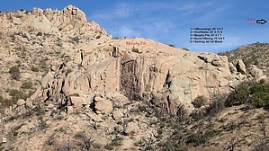
It's not just a theory, but a law, like gravity.
by pseudalpine

S_1864.jpg?V=0.jpg
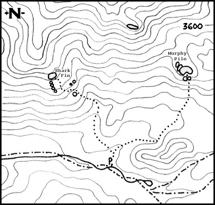
This somewhat significant slab is located east-southeast of the Upper Horrell trailhead parking loop and can be seen from the lower north Sycamore camp (if one walks slightly up the gravel bed to the fence). The first climbed route here was completed over Thanksgiving weekend in 1999 with my younger brother Loren. He had a great Brittany hunting and trail dog named Murphy who had hiked the Reavis Gap Loop with him the day before we climbed this route.


Originally named Murphy Law, this route is inadvertently namesaked as Murphy Pile on the topo, which is a silly double pun about gravity, climbing, and the particular shape this slab depicts. Perhaps Bigfoot of the Reevis Mountain School has another name for it, but MP is what we call it for short. The other routes on each side of this main center dihedral were all added at different times post-Woodbury Fire. This was a blessing in disguise because that extremely hot fire, unfortunately, did some serious damage to much of the Supes and this slab by cooking many of the good flakes and rails to brittleness and essentially covering the wall with a thick, nasty layer of black soot. It's cleaned up well since 2019 and is a great introductory area for Campaign Crystalline climbing.
remove free decal offer
There are two approach options: The official route starts on the east side of the Sycamore camp heading southeast up the pebbly wash and over the fence. A right turn at the first indistinct fork gains a low southeast bearing ridge (some catclaw) eventually switch backing up toward a notch between the large boulders located just below the west face of the slab. The second choice is to follow the major wash (Granite Wash) from the Upper Horrell parking loop, east southeast, then east at a fork (much brushier approach) until reaching a point that accesses the southern side of the pile. The base of this slab is at the Gila/Maricopa County line.

2024-01-07 pseudalpine
  • Shark Fin & Murphy Pile
    guide related
    Shark Fin & Murphy Pile


Check out the Official Route and Triplogs.
Leave No Trace and +Add a Triplog after your climb trip to support this local community.
WARNING! Hiking and outdoor related sports can be dangerous. Be responsible and prepare for the trip. Study the area you are entering and plan accordingly. Dress for the current and unexpected weather changes. Take plenty of water. Never go alone. Make an itinerary with your plan(s), route(s), destination(s) and expected return time. Give your itinerary to trusted family and/or friends.

 Permit $$
no fees or permits reported

if incorrect tell us about it


 Directions
or
 Road
FR / Jeep Road - Car possible when dry

To Upper Horrell Trailhead
From SR 188 turn off onto 449 (also called J-B) just past milepost 235 Follow 449 about two miles to the junction with Cross P Ranch. FR449A is located through the white fence to the left of the Ranch. FR449A is said to be possibly used by high clearance vehicles. I wouldn't recommend. There are some deep sections of sand as well as a couple creek crossings. This is no place to get stuck, no cell phone signal and a long day hike back to SR88. Follow FR449A about six miles to the Upper Horrell(Campaign) Trailhead parking. Along FR449A notice the awesome slot canyon passed along the way.

From PHX (I-10 & AZ-51) 112 mi - about 2 hours 25 mins
From TUC (Jct 1-10 & Grant) 154 mi - about 3 hours 28 mins
From FLG (Jct I-17 & I-40) 178 mi - about 4 hours 18 mins
page created by HAZ_Hikebot on Jan 13 2010 12:37 pm
 90+° 8am - 6pm kills
helpcorrectionissue

end of page marker