Route Editor

| Guide | ♦ | 23 Triplogs | 0 Topics |
details | drive | no permit | forecast | route |
stats |
photos | triplogs | topics | location |
| 441 | 23 | 0 |
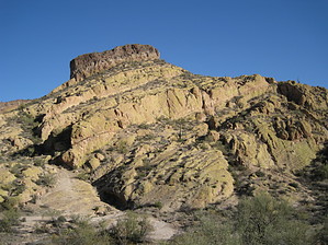
Join The The Mad Hatter Club by AZLOT69  Overview OverviewIf you approach this hike as described, the surprise comes later in the hike. From the west, the mountain looks like it is wearing a top hat. The hat, as it turns out, is a facade. The hat is a dark volcanic ridgeline on top of the golden hill. Circling counterclockwise halfway thru the hike offers some of the best views of this golden, lichen-covered hill wearing the dark top hat. Warning Top Hat Loop is a route as opposed to a trail. It is an off-trail bushwhack for seventy-five percent of the hike. To avoid Sonoran reptiles, hike in cooler weather. Sturdy footwear is a plus.
A quarter-mile north of the Rock House Trail on the Packsaddle Trail is an old jeep road on the left. This is your trailhead. The old jeep road is a dead end, and it proceeds west up a hill's face. Shortly before it ends, there is a wide spot in the road with a fireplace pit. Leave the jeep road and go right or north here. The idea is to follow the contour of this hill around to the northwest, taking the path of least resistance. Try not to gain any elevation as you will have to give it back. Continuing around will bring you to a wash that runs between the two hills on your right and left. Start up the left side bank of the wash, which is pretty deep at this point. Where the wash levels off cross over right. The rest of the way up to the saddle will be spent either in the wash or the right side of the wash. The saddle is home to some old Saguaros and distant views. After enjoying the views, start up your next objective, which is on your left. The hill seems terraced and is relatively easy to serpentine. Working around the left side, head south towards the lower of the two peaks. There is a lone Saguaro on the lower peak. There is a narrow ridgeline here with some interesting quartz inlay, and your objective lies to the southwest. You will have to work down from the lower peak and follow the contour over to the saddle between the two peaks avoiding the rock outcroppings. The saddle has some interesting barrel cactus. Now make your ascent to Hat Top. The peak offers views in all directions. Now look back at the smaller peak with the lone Saguaro. Follow the golden ridgeline to the left of the Saguaro with your eyes. It runs for a couple hundred feet and then ends. That is where you want to go. Work your way down the peak towards the right, following the contour towards the wash in front of that ridgeline. After crossing that wash go up to the base of the ridgeline and follow it left down the slick rock to its end. At its end, turn right. There are a couple of Palo Verdes ahead. Work your way up towards and around them. There is a natural arch behind them in the volcanic rock. You can walk up to this arch from either side. It's like looking out a picture window with lovely views both ways. This is an interesting area geologically to explore. Return the way you came down to the base of the ridgeline, turn right and continue down the incline in a general westerly direction. Cross the wash when appropriate, now taking a more southwest direction. You are heading for a slick rock wash at the bottom. Once at this wash, go left. Soon the wash becomes an old jeep road. Take the road as it offers some great views of the illusion the facade provides for the peak you just bagged. The jeep road comes out to the Rock House Trail. Go left and take the trail to the saddle ahead. There is a large boulder at the saddle. Continue over the saddle to the next large boulder on your left. Look left and up at the rock outcropping. Another natural arch. Leave the Rock House Trail at this point, go over to the boulder and pick up the trail. Yes, a real trail at this point. This trail will complete the loop, passing thru a scenic saddle and back to join the jeep road at the trailhead. Check out the Official Route and Triplogs. Leave No Trace and +Add a Triplog after your hike to support this local community. | |||||||||||||||||||||||||||||||||||||||||||||||||||||||||||||||||||||||||||||||||||||||||||||||||||||||||||||||||||||||||||||||||||||||||||||||||||||||||||||||||||||||||||||||||||||||||