Route Editor

| Guide | ♦ | 7 Triplogs | 0 Topics |
details | drive | no permit | forecast | route |
stats |
photos | triplogs | topics | location |
| 75 | 7 | 0 |
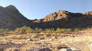
3 Hump Summit by Marana_hiker  Hike HikeThe trailhead begins on an old rocky road with a "No Motorized Vehicles" sign. This quickly turns into a very rocky 5-8' wide pathway with a moderate ascent. The "road" crosses a small gully and leads to a saddle at about 0.5 miles. There is a reasonably recognizable trail from the saddle generally heading up and WSW on a ridge. As you ascend, you will see a large outcropping. You can't see the peak until later in the climb. Pass right of the outcropping and continue upwards. At this point, I came across numerous faint trails, but these trails had few switchbacks, and one route was generally as good as another. There is little vegetation or slope variance so choosing a way up is not critical. Without seeing the peak itself, I veered a bit more WNW as I wanted to visit the memorial to Loren Leonberger, a helicopter pilot who died attempting to land at a mining site in January 2011. Wherever you happen to ascend on the east side of Waterman Peak, you should see the white cross off to the north. There is a white cross, plaque, and a pair of boots hanging from the cross.
The summit is narrow and consists of 3 humps, with a very inconveniently-placed palo verde growing between two of them. My GPS showed the middle hump to be 2' higher than the westernmost, but who knows. The GPS indicated 3834' but Gaia, Avenza, and Route Scout recorded an altitude of less than 3800'. The views of all the southern Arizona mountain ranges are great, as are views of the Silver Bell Mine to the north and the Waterman mine almost directly below the summit on the west side. (A quarry driver I stopped and talked to on Johnstone Rd said this mine, which he called Waterman, is a rock quarry which produces everything from pea gravel to large boulders.) I did not find a logbook at the summit. My ascent took about 1h 25m, which included the stop at the memorial, and the descent took just about an hour. I was doing this with a mildly fractured big toe (not hiking related), so this trail shouldn't be particularly difficult for hikers who have any experience hiking off-trail or on non-NP/Forest Service trails. I didn't try to follow trails on the descent until reaching the old roadbed but found that my route was almost identical to the ascent except for the detour to the memorial. Trail Conditions Some rocks on the trail are extremely sharp. I do a lot of bushwhacking in the Tortolitas. Some of the granite on those peaks can shred clothing if you aren't careful (bushwhacking only, not on the established trails), but it is not nearly as sharp as some of the igneous rocks here. Most of the rocks are not sharp, but some are. I used leather gloves on the final ascent. The rocks here didn't appear to be as sharp, but I didn't want to find out. There is some scree along portions of the trail, but rocks are firmly in place to prevent this from becoming an issue in most places. I found my trekking pole useful but not necessary. Any path you choose will be open, and you will only have to dodge the ocotillos and occasional cactus. Wildlife I almost became very close friends with a rattlesnake coiled in a shadow on an animal trail on the descent, so always watch where you are stepping and placing your hands. I saw several deer near the trailhead but didn't spot any of the bighorn sheep. Environmental Note This route is fully exposed to the sun from sunrise until at least mid-afternoon. There are only a couple of outcroppings which could provide a small amount of shade. Water, sunblock, and early starts are highly recommended. Synopsis I see Waterman Peak on the horizon every day from my home, so I am glad to have made the ascent. The hike itself is open rock from the end of the old road to the summit, with not much variation. Nevertheless, this is an interesting hike with the Leonberger memorial and the great unobstructed views of the Southern Arizona mountain ranges and mines.
Check out the Official Route and Triplogs. Leave No Trace and +Add a Triplog after your hike to support this local community. | ||||||||||||||||||||||||||||||||||||||||||||||||||||||||||||||||||||||||||||||