Route Editor

| Guide | ♦ | 84 Triplogs | 0 Topics |
details | drive | no permit | forecast | 🔥 route |
stats |
photos | triplogs | topics | location |
| 1.7k | 84 | 0 |
Canyons are inherently risky. Flash floods occur without notice on sunny days. Technical skills & surrounding topography knowledge required yet does not eliminate risk.
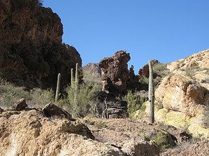
Go prepared! - Caving Checklist Join The Rolling Stones by AZLOT69  Overview OverviewIn the relatively short distance, Rough-N-Ready Canyon traverses between the Javelina Mine Trail and Willow Springs Canyon Lower it transforms from many gentle swales providing drainage for the Golden Hillside Mines area to a wash. It continues, joining with several other tributaries, finally becoming a spectacularly rugged, rocky canyon with walls standing several hundred feet on either side. Warning Flash flood warning. These dry washes and canyons can quickly fill with water, and the water can be intense and violent. Evidence abounds that water at depths over ten feet deep has passed this way. Water will significantly add to the difficulty of this hike as the entire hike is in the waterway.
Follow the Javelina Mine Trail for one-half mile. At one-half mile, take the jeep road to the left. At the top of the hill, look left and right of the road. There is a swale on either side. Going out, take the one on your right. If you return this way, come back via the swale on your left. Either way, the two swales join together and become one just ahead. You may locate some domestic trash in the area, which seems to be from the mining era. The swale is occasionally filled with obnoxious vegetation in this section. You can generally find a way around the right or left of the swale. The swale curves right with some nice monoliths on the horizon. A significant step down in the swale is encountered. This obstacle can be avoided on the left. The swale now becomes a wash with a more defined pathway. The wash alternates back and forth between an easy sandy traverse to a moderate rocky encounter. Soon a cottonwood tree appears. There is another significant step down in the wash here where there appears to be a spring. Even in the driest of times, there is water pooled, although stagnant. Avoid the obstacle on the left. There are two more areas like this just ahead. Both have cottonwood trees with significant steps down in the wash. The second is the more interesting, with a slot carved into the wash. The next obstacle is another significant step-down. This one is about twenty feet and, without ropes, can be avoided on the right. The deep wash now can not be reentered for about two hundred yards. Get back into the wash when possible. At about two miles Quartz Crystal Arroyo joins from the right. The two trails continue thru a canopy of mesquite trees surrounded by golden hillsides. Rough-N-Ready continues as it starts its conversion into a canyon. Countless distractions will draw the curious out of the wash to explore and photograph. Just over a half-mile after passing Quartz Crystal Arroyo, the Packsaddle Trail enters from the left. Rough-n-Ready is now a canyon. The next mile and a half is a thrill. The trail now alternates between an intermediate rock hop to more difficult bouldering, all of which is non-technical. Be alert for natural arches and unusual rock formations. At about three and a half miles into the hike, watch for a cave on the left. As one of the more unusual natural caves in the area, it has a separate entrance and exit, making it all the more special. Back in the canyon, a little more bouldering leads to an easy section and the intersection of Willow Springs Basin and the trailhead for Willow Springs Canyon Lower. You can continue by connecting to these trails or return the way you came. Check out the Official Route and Triplogs. Leave No Trace and +Add a Triplog after your canyon trip to support this local community. | ||||||||||||||||||||||||||||||||||||||||||||||||||||||||||||||||||||||||||||||||||||||||||||||||||||||||||||||||||||||||||||||||||||||||||||||||||||||||||||||||||||||||||||||||||||||||||||||||||||||||