 Route Editor

| Guide | ♦ | 8 Triplogs | 1 Topic |
details | drive | permit | forecast | 🔥 route |
stats |
photos | triplogs | topic | location |
| 69 | 8 | 1 |
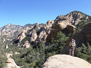
  GET Segment 8 overview GET Segment 8 overviewJaw-dropping. This is the expression that came to mind (and face!) upon the author's first glimpse of Holdout Canyon in the Santa Teresa Wilderness. A wonderland of oddly shaped pinnacles, fins, and domes completely overwhelmed the scene before me, a vantage made all the more incredible by the unexpectedness of it all. Nothing I'd read about the area had quite prepared me for the wilderness of rock I was about to enter. The Santa Teresa Mountains are comprised of an upthrusted and eroded granitic batholith similar in geology and appearance to the "Wilderness of Rock" area of the Santa Catalina Mountains near Tucson, though arguably on a grander scale. Like the Catalinas, the Santa Teresas are a Sky Island range, rising boldly from the surrounding desert and capped with an isolated montane community of flora and fauna. Yet the Santa Teresa Wilderness remains comparatively obscure and is seldom visited, partly owing to the sheer ruggedness of this range's splendor. (Legend has it that the name Holdout Canyon recalls Old West outlaws who once eluded justice among the maze of boulders here.) The other reason for the range's modern-day esoterica relates to trailhead access. Many of the forest roads that approach the Wilderness boundary cross private inholdings with locked gates and no public access, while the few remaining trailheads are accessible only by high-clearance 4WD. (2WD vehicles can access this segment near its endpoints, but foot travel is then required to reach the Forest and Wilderness boundaries.)
Flowing surface water is sometimes in short supply in the modestly-sized Santa Teresas, though the community of Klondyke, as well as nearby Fourmile Canyon Campground, have water available year-round, and springs, rock pockets, stock ponds, and troughs are encountered sporadically along the route. Most long-distance hikers will probably also want to send a resupply parcel to Klondyke, which is located directly along a suggested alternate route. Plan to budget about two and a half days of food between Klondyke and segment's end if going through the Wilderness (not including any downtime in Klondyke environs). A detailed, mile-by-mile description of this segment is available in the official GET guidebook. See https://simblissity.net/get-home.shtml This segment of the GET forms part of a longer trip option between resupply locations, as described below: GET Segments 6 - 11, Mammoth to Safford East of AZ Hwy 77 the Grand Enchantment Trail heads into Sonoran desert foothills of the sky-island Galiuro Mountains, wherein lies the entrance to spectacular Aravaipa Canyon (BLM Wilderness). Sheer canyon walls rise a thousand feet above the lush, deciduous banks of perennial Aravaipa Creek, where we linger, wet feet and broad smiles, for some 12 unforgettable miles. Quiet dirt roads resume east of the canyon, leading within range of the remote outpost of Klondyke - another potential maildrop resupply location - before our route turns northeast to climb into the extreme rugged terrain of the Santa Teresa Wilderness (Coronado National Forest). Little-used trails provide supreme solitude as we navigate the adventurous granite-domed wonderland of Holdout Canyon, then over 7000-foot Cottonwood Mountain near well-named Pinnacle Ridge, and south to reach Klondyke Road. A fun yet challenging cross-country connection culminates at Tripp Canyon, where the GET soon rejoins foot trail to climb high into the forested Pinaleno Mountains (Coronado NF), passing serene Riggs Lake and the view full fire tower atop 10,000-foot Webb Peak, where snow may linger well into spring. The desert heat seems as far away as the distant horizon atop this tallest of Arizona's Sky Island ranges, where broad panoramas reveal such distinguished neighbors as the Rincons, Huachucas, Chiricahuas, as well as the Mogollon Mountains in New Mexico farther along the GET. Leaving the high country by and by, we follow the magnificent craggy defile of forested Ash Creek Canyon on down toward the open desert nearly a vertical mile-and-a-half below, passing through an astonishing range of life zones in only a few miles of travel. Finally, the route joins quiet greasewood-flanked dirt roads to reach the outskirts of bustling Safford, with most services available. Gate Policy: If a gate is closed upon arrival, leave it closed after you go through. If it is open, leave it open. Leaving a closed gate open may put cattle in danger. Closing an open gate may cut them off from water. Please be respectful, leave gates as found. The exception is signage on the gate directing you otherwise. Check out the Official Route and Triplogs. Note This is a more difficult hike. It would be unwise to attempt this without prior experience hiking. Leave No Trace and +Add a Triplog after your hike to support this local community. One-Way Notice This hike is listed as One-Way. When hiking several trails on a single "hike", log it with a generic name that describes the hike. Then link the trails traveled, check out the example. | |||||||||||||||||||||||||||||||||||||||||||||||||||||||||||||||||||||||||||||||||||||||||||||||||||||||||||


