 Route Editor

| Guide | ♦ | 7 Triplogs | 1 Topic |
details | drive | no permit | forecast | route |
stats |
photos | triplogs | topic | location |
| 11 | 7 | 1 |
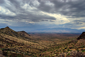
Safford to Bear Spring Canyon by blisterfree  GET Segment 12 overview GET Segment 12 overviewThe Grand Enchantment Trail rejoins cotton-spangled farmland once more as it departs Safford environs, then ascends gradually out of the Gila Valley and into the Gila Mountains on our tour of this segment. The Gila Mountains of Arizona are of course not to be confused with the Gila National Forest in New Mexico, farther ahead on our route. This comparatively low-elevation mountain range is fault-block in origin, a colorful, rock-studded upheaval that delineates the broad Gila Valley for many miles on its north. The geology changes markedly as we enter this high-desert range. Gone from the surface environment are the sturdy granites, gneisses, and schists that form the heart and character of the Pinaleños, Santa Teresas, and other sky island ranges, replaced instead by the cobbly sedimentary and volcanic rock of the Gila Conglomerate. As is common throughout southeastern Arizona, the mineral copper is abundant in this area, a fact that has not gone unnoticed by mining interests over the years. In 2005, the Phelps-Dodge Corporation (now Freeport-McMoRan) secured plans to develop a pair of open-pit mines in the Gila Mountains west of our route and only a few miles north of Safford, a boon to the rural economy here, if in some ways a transformation of the town's very soul. And so our route looks on from afar, offering vantages from this range of the distant past, the heady present, and an uncertain future.
A detailed, mile-by-mile description of this segment is available in the official GET guidebook. See https://simblissity.net/get-home.shtml This segment of the GET forms part of a longer trip option between resupply locations, as described below: GET Segments 12 - 14, Safford to Morenci & Clifton The Old Safford-Morenci Trail follows a former trade route between the two towns from which it finds its name. The GET follows quiet, viewlishish dirt roads and washes north of Safford to join this BLM-administered historic trail in the high desert Gila Mountains of Arizona, where developed singletrack trail, old roads, and cairned drainage courses make for interesting, remote, and highly varied trekking. Colorful box canyons lead into and out of the secluded riparian corridor of Bonita Creek about halfway along, and beyond the route climbs to Bellmeyer Saddle, a scenic grassy expanse at 6000 feet in elevation. Descending to Eagle Creek in its rugged, winding gorge - prime bighorn sheep country - an alternate route soon climbs away, while the main GET turns north, following Eagle Creek's canyon upstream, with numerous (though generally mild) fords. The white-nosed coati is often seen cavorting among sycamores and cottonwoods in the creekside riparian forest. At length, the Painted Bluff Trail leads us east away from the river, along the way offering glimpses of ancient petroglyphs in a high-desert mountain landscape rich with solitude. Views at last open toward the vast open-pit of the Morenci copper mine as our route descends to cross the Coronado Trail Scenic Byway, a famously serpentine paved auto route with potential opportunities for a ride into Morenci village. Historic Clifton, another resupply option, lies several miles farther downhill, a virtual living history museum to the region's early mining days. Check out the Official Route and Triplogs. Leave No Trace and +Add a Triplog after your hike to support this local community. One-Way Notice This hike is listed as One-Way. When hiking several trails on a single "hike", log it with a generic name that describes the hike. Then link the trails traveled, check out the example. | |||||||||||||||||||||||||||||||||||||||||||||||||||||||||||||||||||||||||||||||||||||||||||||||||


