Route Editor

| Guide | ♦ | 18 Triplogs | 0 Topics |
details | drive | permit | forecast | route |
stats |
photos | triplogs | topics | location |
| 187 | 18 | 0 |
Canyons are inherently risky. Flash floods occur without notice on sunny days. Technical skills & surrounding topography knowledge required yet does not eliminate risk.
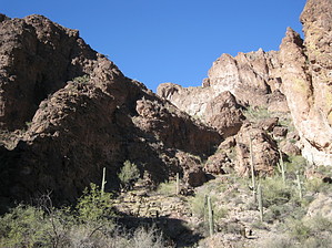
Among Goldfield Skyscrapers by AZLOT69  Overview OverviewWillow Springs Canyon Lower is more of a route than a trail but it is a well-defined route staying in the waterway the entire length to its junction with Saguaro Lake. Awe-inspiring cliffs, hundreds of feet tall, line the canyon on both sides providing non-stop scenery. Rock hopping turns to bouldering as the canyon narrows to a slot with one technical section in which many are going to need a rope to assist for the final stretch to the water. Warning Flash flood warning. This normally dry canyon can fill with water quickly and the water can be strong and violent. Evidence abounds that water at depths over ten feet deep has passed this way. Water will significantly add to the difficulty as the entire hike is in the waterway.
The trailhead has several nice sites suitable for primitive camping. Starting at the junction with Rough-N-Ready Canyon and the Willow Springs Basin, the Willow Springs Canyon Lower heads in a north northwest direction. The smooth sandy canyon bottom quickly becomes a rock hop. Pick and choose the best path downstream. Towering cliffs offer ample opportunity for photo taking, looking for wildlife, and simply enjoying the splendor of this canyon. The canyon turns and twists with new exciting views around each corner. Winter hiking with the sun at extreme angles can have you in the shade much of the day and present some challenges in taking photos with the dark shadows. On the flip side, a summer hike would be like a convection oven with the sun straight overhead. There are several sections where light bouldering is required as well as the use of hands. Sturdy footwear and walking sticks are a plus due to all the ankle-twisting rocks and the inclination to look up constantly. There are several opportunities for side trips and it can make it difficult to make any forward progress in the canyon. The trail eventually narrows down to a short slot section in which you can touch the walls on either side at the same time. Soon you may hear boats on Saguaro Lake. The noise echoes up the canyon. You are approaching Saguaro Lake but it is still out of sight. Keep in mind that the level of the lake can change quickly because it is regulated by the dam. With this in mind, you approach the final obstacle. A fifteen-foot drop down some boulders. There is no bypass. Consider your options before continuing. If you go down can you get back out? Scramblers can negotiate this especially if you have a partner. Setting up a rope assist is a good option. Others will use this as a reason to turn back and return the way you came. Check out the Official Route and Triplogs. Leave No Trace and +Add a Triplog after your canyon trip to support this local community. | |||||||||||||||||||||||||||||||||||||||||||||||||||||||||||||||||||||||||||||||||||||||||||||||||||||||||||||||||||||||||||||||||||||||||||||||||||||||||||||||||||||||||||||||||||||||||||||||||