username
X
password
register
for free!
help
  🔥

Massacre Falls Loop - First Water TH, AZ

Guide 20 Triplogs  2 Topics
  2.9 of 5  
Fav
Wish
7
details
drive
no permit
forecast
🔥
route  
stats
photos
triplogs
topics
location
339 20 2
Statistics
tap row or icons for details
Difficulty 3 of 5
Route Finding 3 of 5
Distance Loop 6.85 miles
Trailhead Elevation 2,290 feet
Elevation Gain 1,007 feet
Accumulated Gain 1,375 feet
Avg Time Round Trip 4 hours
Kokopelli Seeds 13.73
 Interest Off-Trail Hiking, Seasonal Waterfall & Perennial Waterfall
 Backpack Yes
feature photo
Photos Viewed All MineFollowing
Will recalculate on button tap!
5  2023-06-28 pseudalpine
8  2022-12-01
Praying Hands Loop from Crosscut TH
Yoder
25  2022-02-19
Massacre Arch via First Water Trailhead
John10s
12  2020-02-23 survivordude
5  2019-12-29
Massacre Falls Arch
hikingaz2
24  2019-11-16
First Water Reverse Flatiron
mr_squishy
35  2019-02-04 mr_squishy
29  2017-04-16 KBKB
Page 1,  2
Author
author avatar Guides 1
Routes 12
Photos 281
Trips 45 map ( 372 miles )
Age 72 Male Gender
Location Chandler, Az
Associated Areas
list map done
Phoenix Region
Historical Weather
Trailhead Forecast
Radar Map
Expand Map
Preferred Feb, Jan, Dec, Nov → 8 AM
Seasons   Autumn to Spring
Sun  6:02am - 6:47pm
Official Route & 3 Rts
 
5 Alternative
 
Historic Fire Perimetersacres
🔥 2024 Siphon Fire35.9 mi*
🔥 2020 Superstition Fire9.6k
🔥 View (All) - over Official Route 🔥
*perimeter length in miles


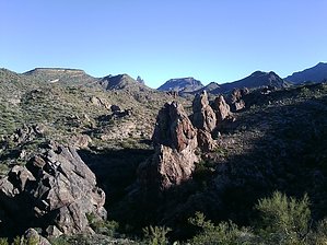
Amazing views & Waterfalls
by azhunt2012

Overview
An excellent mini-adventure to Massacre Falls through a hidden tributary of First Water Creek. Then looping a return past the old Massacre Trailhead. A GPS unit loaded with the Default Route will be very helpful in getting you to Massacre Falls.


Hike
From the First Water Trailhead follow the Dutchman Trail #104 for 1.3 miles to the first major crossing. Here you turn right off trail and follow the creek. This tributary flows almost as hardy as First Water itself.
remove free decal offer
You have to do a little bushwhacking as you follow First Water Creek for about 0.2 miles until you turn southwest up the draw. Caution should be used during stormy conditions. You need to watch for flash flooding. After the turn, follow the draw up through a small streambed that is overgrown with catclaw, Teddybear Cholla, and other nasty things that tend to stick you. This continues for about 0.7 miles to the first saddle. From this point, you can see Massacre Falls, a dark vertical stripe that is 1.2 miles to the west. Continue down the draw and back up through the saddle across some easy rock face terrain. Proceed down one last time to the bottom of Massacre Grounds before you start the climb to the falls.

Next comes the ascent to the falls. When the creek is running you can hear the falls in the distance. Finding the falls is nothing difficult. However, it can be a route-finding challenge. Generally, the most traveled route gets you to the falls. It would be advisable to study the map to understand the route. Two or three cairned routes get you to the falls and one takes you far away to West Boulder Canyon.

At this point, you can see pleasant views of rolling hills, unique rock formations, and the rugged beauty of Superstition Mountain. Upon reaching the falls, intermittent cascades tumble over a wide cliff face after heavy rains.

After an enjoyable break at the base of the falls, follow the Massacre Trail back to the old Massacre Trailhead (it's the fence line) that is now closed. When in season, wildflowers dominate the foothills at the trail's end. There is an old road along the fence line to your right that will return to FR-78 after some traversing across easy lower desert terrain. You can see the overflow parking lot for First Water TH in the distance (about 3/4 mile). There is a restroom with no water. From there you can pick up the Dutchman's Trail# 104 on the north side of the road and follow it to the First Water Trailhead.

2010-02-07 azhunt2012


    Check out the Official Route and Triplogs.
    Leave No Trace and +Add a Triplog after your hike to support this local community.
    WARNING! Hiking and outdoor related sports can be dangerous. Be responsible and prepare for the trip. Study the area you are entering and plan accordingly. Dress for the current and unexpected weather changes. Take plenty of water. Never go alone. Make an itinerary with your plan(s), route(s), destination(s) and expected return time. Give your itinerary to trusted family and/or friends.

     Permit $$
    None


     Directions
    or
     Road
    FR / Jeep Road - Car possible when dry

    To hike
    page created by azhunt2012 on Feb 06 2010 6:10 pm
     90+° 8am - 6pm kills
    helpcorrectionissue

    end of page marker