Route Editor

| Guide | ♦ | 17 Triplogs | 0 Topics |
details | drive | no permit | forecast | 🔥 route |
stats |
photos | triplogs | topics | location |
| 336 | 17 | 0 |
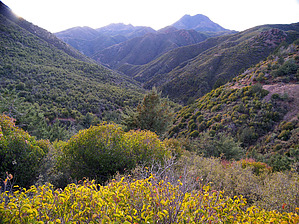
mercury madness revisited by PrestonSands   Overview: This hike uses early 20th-century mine roads to take one from the East Fork of Sycamore Creek to the West Fork, in Arizona's Mazatzal Mountains. Why hike this jeep trail? Because if you don't have a high clearance, four-wheel-drive jeep, you won't otherwise get to see this beautiful stretch of Mazatzal country, with its green hills, narrow canyons, and one-hundred-year-old mercury mines. This hike also creates an optional starting point for the Cornucopia-Thicket Spring Loop and Saddle Mountain Mine Tour hikes. Overview: This hike uses early 20th-century mine roads to take one from the East Fork of Sycamore Creek to the West Fork, in Arizona's Mazatzal Mountains. Why hike this jeep trail? Because if you don't have a high clearance, four-wheel-drive jeep, you won't otherwise get to see this beautiful stretch of Mazatzal country, with its green hills, narrow canyons, and one-hundred-year-old mercury mines. This hike also creates an optional starting point for the Cornucopia-Thicket Spring Loop and Saddle Mountain Mine Tour hikes.History: Mercury ore, in the form of cinnabar, was discovered on the West Fork of Sycamore Creek in 1911 by E.H. Bowman. A flurry of prospecting activity followed, resulting in ten other groups of claims in the Sycamore and Slate Creek areas by 1926. Mercury mining continued sporadically in the area until about the 1960s. This hike passes by Oneida Mine on the L&N claim group and Cornucopia Mine on the Robbins claim group.
The Cornucopia Mine was active from around 1921 to 1925. A camp existed near the mine, consisting of a blacksmith shop and a compressor building, along with dining and bunkhouse tents for the miners. Little remains at the Cornucopia Mine, but the Oneida Mine's extensive tunnels are intact and might make for an interesting exploration. Be careful, and should you see any droplets of silvery liquid in the mine, I suggest that you do not touch them. Martin's cabin, which stood intact until at least the early 1980s, is gone, but the foundation remains. Hike: From the road junction (33.96775 N, 111.45003 W) on Forest Road 201, Forest Road 201A (this hike) drops off the ridge top into a short side canyon of East Fork Sycamore Creek, among Arizona cypress trees and thick chaparral. It soon becomes apparent why hiking this road rather than driving is the best choice, as the road negotiates massive washouts and boulder-filled creek beds. Emerging from the side canyon at 0.7-miles, our road arrives at the East Fork of Sycamore Creek. A spur road to the left leads a short distance to an abandoned mercury retort and what may have been the foundation of a mercury mill. Our road turns upstream (right) and passes over Chris Martin's old cabin's cement pad, before crossing the creek and reaching the abandoned tunnels of the historic Oneida Mine. Leaving the mine site, our road turns south to ascend a steep little side canyon. There are some great views of Pine Mountain and the East Fork as the road gains elevation. The route makes a circuitous climb out of the cypress filled side canyon and finds itself on a ridge, which follows up to the divide between the East Fork and West Fork of Sycamore Creek. The ridge offers an exceptional view of the southern Mazatzals and the distant Sierra Ancha. Arriving at the Sycamore Creek divide, Forest Road 201A reaches a four-way intersection and the hike's high point at 2.2-miles (33.96808 N, 111.47106 W). Continue straight on Forest Road 3722, which descends the west side of the divide. This steep and rocky stretch features views of Mazatzal Peak and Mount Peeley, with Saddle Mountain to the west. Once it drops to a saddle at 5200 feet, our road turns south to descend a side canyon of the West Fork of Sycamore Creek, among cypress, crumbly purple slate, and the upper workings of the Cornucopia Mine. A steep descent on the loose rock of Forest Road 3722 soon deposits you at the bottom of the West Fork at 3-miles (33.9657 N, 111.4813 W). A left turn to follow Forest Road 25A (along the route of the Saddle Mountain Mine Tour hike) will take you to the Sunflower Mine site in just over a mile. A right turn follows the Cornucopia Trail #86 up the West Fork, taking you to the historic Cornucopia Mine location in 0.15-miles. Continue past the Cornucopia Mine for a half-mile to tie into the route of the Cornucopia-Thicket Spring Loop hike. Check out the Official Route and Triplogs. Leave No Trace and +Add a Triplog after your hike to support this local community. | |||||||||||||||||||||||||||||||||||||||||||||||||||||||||||||||||||||||||||||||||||||||||||||||||||||||||||||||||||||||||||||||||||||||||||||||||||||||||||||||||||||||||||||||||||||||||||||||||||||||||||||||