username
X
password
register
for free!
help
 This is likely a great time to hike this trail!  Check out "Preferred" months below, keep in mind this is an estimate.
 

East Rim Trail #7, AZ

Guide 15 Triplogs  0 Topics
  3.9 of 5  
Fav
Wish
0
details
drive
no permit
forecast
route  
stats
photos
triplogs
topics
location
123 15 0
Statistics
tap row or icons for details
Difficulty 4 of 5
Route Finding 1 of 5
Distance One Way 1.85 miles
Trailhead Elevation 8,858 feet
Elevation Gain -1,419 feet
Accumulated Gain 18 feet
Avg Time One Way 1 - 2 hours
Kokopelli Seeds 1.91
 Backpack Possible & Connecting
feature photo
Photos Viewed All MineFollowing
14  2020-10-29
East North South Loop
chumley
9  2020-07-29 FOTG
22  2020-05-24 ultrazona
4  2019-09-01
North Canyon Trail #4
ShatteredArm
15  2018-08-05
East Rim - North Canyon Loop
BiFrost
8  2018-05-26
Canyons and Cockscombs loop
toddak
52  2013-09-02
Rainbow Rim Trail
tibber
5  2012-10-10 joebartels
Page 1,  2
Author
author avatar Guides 16,843
Routes 17,472
Photos 24
Trips 1 map ( 6 miles )
Age 28 Male Gender
Location HAZ, TrailDEX
Associated Areas
list map done
Northwest Region
Historical Weather
Trailhead Forecast
Radar Map
Expand Map
Preferred Sep, May, Jun, Aug → 1 PM
Seasons   Late Spring to Early Autumn
Sun  6:03am - 6:51pm
Official Route & 2 Rts
 
3 Alternative


remove free decal offer
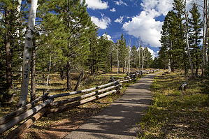
dandy, nifty, swell - you decide
by HAZ_Hikebot

 Likely In-Season!
Beginning at East Rim Viewpoint, Trail #7 makes a steep descent down the rim of North Canyon, passing through mixed conifer forests, oak thickets, ferns, and rock cliffs, before joining the two forks of North Canyon Trail #4 at the bottom. Because of the steep-sided and narrow pathway on this trail, riders should use only experienced trail horses.


This trail provides an alternate entrance or exit connecting to Trail #4 in the Saddle Mountain Wilderness. It descends from East Rim Viewpoint into North Canyon, where it joins Trail #4.

2018-07-14 HAZ_Hikebot


    Check out the Official Route and Triplogs.

    Note
    This is a moderately difficult hike.
    Leave No Trace and +Add a Triplog after your hike to support this local community.

    One-Way Notice
    This hike is listed as One-Way.

    When hiking several trails on a single "hike", log it with a generic name that describes the hike. Then link the trails traveled, check out the example.
    WARNING! Hiking and outdoor related sports can be dangerous. Be responsible and prepare for the trip. Study the area you are entering and plan accordingly. Dress for the current and unexpected weather changes. Take plenty of water. Never go alone. Make an itinerary with your plan(s), route(s), destination(s) and expected return time. Give your itinerary to trusted family and/or friends.

     Permit $$
    no fees or permits reported

    if incorrect tell us about it


     Directions
    or
     Road
    FR / Dirt Road / Gravel - Car Okay

    To hike
    Trailhead at 8,810 feet in the Saddle Mountain Wilderness at East Rim Viewpoint.

    From North Kaibab Visitor Center go south on State Highway 67, 26.5 miles (0.7 miles beyond Demotte Campground entrance) and turn east onto FR 611; in 1.4 miles FR 611 intersects FR 610; continue on FR 611 for 2.6 miles to East Rim Viewpoint where Trail #7 starts at the Wilderness boundary.

    About one hour from North Kaibab Visitor Center.

    Road Conditions: Forest Roads 611 and 610 are suitable for sedans in dry weather. AZ 67 is closed after the first winter snowfall.
     90+° 8am - 6pm kills
    helpcorrectionissue

    end of page marker