 Route Editor

| Guide | ♦ | 58 Triplogs | 0 Topics |
details | drive | permit | forecast | 🔥 route |
stats |
photos | triplogs | topics | location |
| 403 | 58 | 0 |
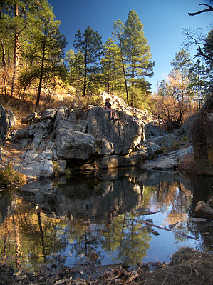
 Overview OverviewThis trail should not be confused with the other Goldwater Lake Trail within the City of Prescott's Goldwater Lake Park. Goldwater Lake Trail #396 is a new section of the Prescott Circle Trail between White Spar Campground and the Senator Highway. The new Goldwater Lake Trail #396 rambles through gentle pine-covered hills, passing both Lower and Upper Goldwater Lakes along the way. This winding trail is well marked and easy to follow. Hike Beginning at the White Spar Campground trailhead along U.S. Highway 89, the Goldwater Lake Trail departs next to a locked vehicle barrier gate. Initially following a road up Schoolhouse Gulch, the trail quickly breaks to the left at a fiberglass signpost for trail #396 and climbs into low hills of mixed ponderosa and oak. Along the way, trails Twist & Shout Trail #372 and Hidden Valley Trail #374 break off to the left at 0.25 and 0.7 miles, respectively.
Leaving Bannon Creek behind, the trail climbs the south bank to contour around pine-covered hillsides, eventually passing near Lower Goldwater Lake, which is barely visible through the trees. The trail reaches a low saddle at just over three miles, where it begins a lengthy u-turn descent to the broad basin where Upper Goldwater Lake lies. The Goldwater Lake Trail #396 approaches the lake from the south but does not go to it. Instead, a short bypass trail travels to the lakeshore, where it meets the shoreline route of the Goldwater Lake Trail. The bypass trail rejoins the Goldwater Lake Trail #396 within a quarter of a mile. The Goldwater Lake Trail #396 continues east, leaving the lake area and crossing Bannon Creek once more, before ascending a bit through open forest and boulders to the east trailhead on the Senator Highway, at 4.5 miles. One can continue hiking from the east trailhead by taking the Watershed Trail #299, located directly across the highway. Gate Policy: If a gate is closed upon arrival, leave it closed after you go through. If it is open, leave it open. Leaving a closed gate open may put cattle in danger. Closing an open gate may cut them off from water. Please be respectful, leave gates as found. The exception is signage on the gate directing you otherwise. Check out the Official Route and Triplogs. Leave No Trace and +Add a Triplog after your hike to support this local community. One-Way Notice This hike is listed as One-Way. When hiking several trails on a single "hike", log it with a generic name that describes the hike. Then link the trails traveled, check out the example. | |||||||||||||||||||||||||||||||||||||||||||||||||||||||||||||||||||||||||||||||||||||||||||||||||||||||||||||||||||||||||||||||||||||||||||||||||||||||||||||||||||||||||||||||||||||||||||||||||||||


