Route Editor

| Guide | ♦ | 3 Triplogs | 0 Topics |
details | drive | permit | forecast | map |
stats |
photos | triplogs | topics | location |
| 104 | 3 | 0 |
Canyons are inherently risky. Flash floods occur without notice on sunny days. Technical skills & surrounding topography knowledge required yet does not eliminate risk.
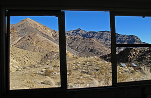
- One of DVs Hidden Gems - by Grasshopper  For day hiking and backpacking, the south fork is the most scenic part of Trail Canyon. In this lower canyon the colorful and well preserved Morning Glory camp (at 4255ft), its small perennial spring, and the Old Dependable Antimony Mine are all a short driving and hiking distance from the main Trail Canyon entrance road. The very best part of hiking the south fork is the old Morning Glory Mines, on a high, forested ridge (at 6350ft) at the far end of the south fork's rugged narrows with clear views of close Wildrose Peak. With its unlikely tramway, spectacular 1.8 mile rugged mine road (switch-backing up 1450ft), and with its beautiful ore specimens, this hike to the high Morning Glory Mines is an excellent example why Trail Canyon and its South Fork are truly one of Death Valley's hidden gems.
History: The Trail Canyon area of Death Valley has a 250-million-Year Geology Record and witnessed a fair amount of mining, betrayed today by numerous sites. First it was gold in March 1906, with three active companies mining. By the spring of 1907 all three companies had folded. Trail Canyon came alive again thirty-some years later with the discovery of antimony. From 1939 to 1941 around $50k was invested in the Old Dependable Antimony Mine Complex (which this hike passes by in the South Fork of Trail Canyon). These mines produced about 70 tons of high-grade ore before the operations were suspended during World War II. Next it was the discovery of rare tungsten in the South Fork of Trail Canyon at the high Morning Glory Mines and at the Broken Pick Millsite. Tungsten mining was still going on in the South Fork as late as 1971, but it is doubtful that the financial return was ever substantial. Drive-in and Hike: The DRIVE-IN for this hike description has two recommended and posted GPS Routes discussed below in the Driving Directions section: "First"- Drive to/visit the colorful, well-preserved "Broken Pick Millsite & Mine Camp", then "Second"- Drive to/visit the even more colorful, well-preserved "Morning Glory Mine Camp". After mandatory photo shoots, here is where your HIKE TH begins (at way point N36.30335 W-117.04780) for your 3 mile one way hike further up the South Fork of Trail Canyon, past perennial Morning Glory Spring (at way point N36.30267 W-117.04835), past the site of the Old Dependable Antimony Mine, and onward (1.1ml from TH Start) to the easy to miss canyon intersection with the continuing 1.8 mile, obscure, rugged, 1450 feet uphill, switch-back Morning Glory Mine Road (at way point N36.28930 W-117.05155). At 6350 feet after hiking up this spectacular mining road, at 3.0 miles in from your TH Start, you should arrive at this Death Valley gem location- the High Morning Glory Mines (at way point N36.28156 W-117.06104). Please Note: This hike description is written as an "in and out" hike, but it is possible to make a lasso loop out of this hike for a 5.2 mile R/T vs a 6.0 mile in and out R/T, but a more time consuming and rugged day hike. The author's recommended route from the same TH Start for a lasso loop: first hike to, then up the 1.8 mile mine road to the Morning Glory Mines, then ~1.2 miles down the beautiful but rugged and narrow unnamed canyon to the west of the Morning Glory Mines (with some time consuming high dry/wet waterfalls to negotiate down and/or around). This unnamed canyon is beautiful but can be very slow, demanding, and time consuming so plan accordingly IF you elect to try it. On 2/18/10, two of us tried this lasso loop going the opposite direction, and started hiking too late in the day with snow and wetness in the upper reaches of this unnamed canyon, and turn around in barely enough time to reach our TH Start before dark (My posted 2/18/10 GPS Hiking Route details this lasso loop attempt). Check out the Triplogs. Leave No Trace and +Add a Triplog after your canyon trip to support this local community. | |||||||||||||||||||||||||||||||||||||||||||||||||||||||||||||||||||||||||||||||||||||||||||||||