 Route Editor

| Guide | ♦ | 16 Triplogs | 4 Topics |
details | drive | no permit | forecast | 🔥 route |
stats |
photos | triplogs | topics | location |
| 4 | 16 | 4 |
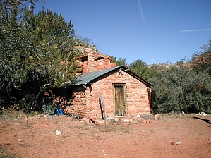
Dogie Flipside by HAZ_Hikebot   Just getting to this trail is an adventure. The last mile of primitive road that leads to the trailhead is a place of tire bruising rocks and bottom scraping ruts. It might be a good idea to hike or mountain bike it, so you don't abuse your car driving it. Don't try it at all without a sturdy, high clearance vehicle. There is an FS/APS gate about 300 yards from the trailhead sign. Just getting to this trail is an adventure. The last mile of primitive road that leads to the trailhead is a place of tire bruising rocks and bottom scraping ruts. It might be a good idea to hike or mountain bike it, so you don't abuse your car driving it. Don't try it at all without a sturdy, high clearance vehicle. There is an FS/APS gate about 300 yards from the trailhead sign.Once you get to the trailhead, you'll forget all about that rocky ride. The view is magnificent-Grand Canyon quality. You can see into Mooney Canyon, part of the lower Oak Creek basin, and Sycamore Canyon at the same time. In Sycamore, sheer walls, towering buttes, teetering pinnacles, and colossal lava flows stretch to the horizon. Taylor Cabin Trail provides good views of all this then drops into a sheltered drainage, which it follows to the canyon floor. The steepest part of the climb is mercifully shaded by Douglas firs and ponderosa pines. At trail's end, on the floor of Sycamore Canyon, you'll find everything associated with a desert river except the river itself. Rounded boulders and gnarled sycamore trees attest that water flows here regularly, but unless you come during the snowmelt or after a thunderstorm, you won't see it. Some of the larger pools hold water into late spring, but eventually, they all dry up.
Gate Policy: If a gate is closed upon arrival, leave it closed after you go through. If it is open, leave it open. Leaving a closed gate open may put cattle in danger. Closing an open gate may cut them off from water. Please be respectful, leave gates as found. The exception is signage on the gate directing you otherwise.
Coconino FS Details Just getting to this trail is an adventure. The last mile of primitive road that leads to the trailhead is a place of tire bruising rocks and bottom scraping ruts. Actually, it might be a good idea to hike or mountain bike it, so you don't abuse your car driving it. Don't try it at all without a sturdy, high clearance vehicle. There is a FS/APS gate about 300 yards from the trailhead sign. Once you get to the trailhead you'll forget all about that rocky ride. The view is magnificent-Grand Canyon quality. You can see into Mooney Canyon, part of the lower Oak Creek basin, and Sycamore Canyon at the same time. In Sycamore, sheer walls, towering buttes, teetering pinnacles and huge lava flows stretch to the horizon. Taylor Cabin Trail provides good views of all this then drops into a sheltered drainage which it follows to the canyon floor. The steepest part of the climb is mercifully shaded by Douglas firs and ponderosa pines. At trail's end, on the floor of Sycamore Canyon, you'll find everything associated with a desert river except the river itself. Rounded boulders and gnarled sycamore trees attest to the fact that water flows here regularly, but unless you come during the snowmelt or after a thunderstorm, you won't see it. Some of the larger pools hold water into late spring, but eventually they all dry up. Taylor Cabin, a historic old rancher's shack listed in the National Register of Historic Places, is about a mile and half downstream. You can either boulder hop down the stream bed to it or follow the Sycamore Basin Trail. That trail is directly across the main stream bed from the end of the path you have just walked down. Following the trail is the best way of finding the cabin, otherwise you could boulder hop right past it. Use: Moderate Notes: Bring lots of water-it's hot and steep. No motorized or mechanized vehicles (including mountain bicycles) in the Wilderness. High clearance vehicles only to trailhead. Use experienced trailhorses. USGS Map(s): Loy Butte, Sycamore Point Location: 30 miles south of Flagstaff on graveled and dirt forest roads. Check out the Official Route and Triplogs. Leave No Trace and +Add a Triplog after your hike to support this local community. One-Way Notice This hike is listed as One-Way. When hiking several trails on a single "hike", log it with a generic name that describes the hike. Then link the trails traveled, check out the example. | |||||||||||||||||||||||||||||||||||||||||||||||||||||||||||||||||||||||||||||||||||||||||||||||||||||||||||||||||||||||||||||||||||||||||||||||||||||||||||||||||||||||||||||||||||||||||||||||||||||||||


