Overview
Goat Camp Trail is your southernmost entry to White Tank Regional Park's backcountry. Compared to its two counterparts, Mesquite Trail and Ford Canyon, it is the most strenuous, partially due to its rocky terrain. After the climb up, the reward is a 3-mile, blissful stroll in the heart of the White Tank Mountains.
Hike
From the start of your hike, you are surrounded by classic desert scenery. Several large, rugged outcrops and the broad, tower-infested ridge of Peak 4018 paint the picture in front of you. Though it's tempting to look up, you'll want to watch your step frequently to keep from tripping. The trail crosses Black Canyon's wash just before mile marker one and doesn't get any less rocky. Half a mile later, you'll pass under a couple of mesquite trees to find a perfect rock bench on your left. Have a seat and take a breather. This is where things get fun.
The trail crosses the dry bed of Goat Canyon, followed by several switchbacks before skirting along the slopes of the canyon for half a mile. During this 570ft climb, you'll have great views of the prominent, thumb-like outcrop to the north (I like to refer to it as the Goat Thumb), as well as some incredible cliffs to the south. There will be plenty of time to admire the beautiful scenery as you stop to catch your breath. You'll top out at a nice bed of sand and small dryfall, then do a quick zigzag up some boulders to reach the second-mile marker.
The views continue as you enter a small valley. The once-distant Peak 4018 looms above directly in front of you. While the rockiness subsides slightly, the climbing is yet to be over. Near the head of Goat Canyon, the trail bends to the north and begins a 220ft climb to the top of a ridge. The footing here can be loose, especially on the way down, so use some caution. The ridge makes for a lovely destination; however, turning around here would be a big mistake.
The remaining three miles are the big payoff that makes up for all of your hard work. It is groomed to perfection wherever possible, and despite some minor ups, the majority of it is either flat or very gradual downhill. It's the perfect showcase with views east to the Valley of the Sun, numerous canyons, and the tallest peaks in the White Tank Mtns. The best part is you won't be stumbling with every step you take, so go ahead and stare! When you reach the end of the trail, you can head back the way you came, loop around with Mesquite Trail, or do 11 more miles with Ford Canyon and Mule Deer for the complete White Tank Loop.
Water Sources
None on the trail. There is a spigot at the trailhead.
Camping
The nearest camping is located in the park. See here for details.
When hiking several trails on a single "hike", log it with a generic name that describes the hike. Then link the trails traveled, check out the example.
WARNING! Hiking and outdoor related sports can be dangerous. Be responsible and prepare for the trip. Study the area you are entering and plan accordingly. Dress for the current and unexpected weather changes. Take plenty of water. Never go alone. Make an itinerary with your plan(s), route(s), destination(s) and expected return time. Give your itinerary to trusted family and/or friends.
To Goat Camp Trailhead 101 Loop to Park Take the I-10 west out of Phoenix to the 101 Loop Freeway. Go north on the 101 to Olive Blvd. Take a left and head west 13.5 miles to the White Tank Mountain Park entrance.
I-10 to Park To get to the White Tank Mountain Park from downtown (PHX) is to stay on I-10 to Cotton Lane. Then go North 7 miles to Olive Ave, there is a stop sign and a Fertazone plant on the NW corner. Take a left (west) to the park. By going this you miss the new stop lights and the added stop signs on Olive.
After paying the fee at the entrance station on Olive Ave., continue west and take the first left, which is Black Canyon Drive, then park at the second parking lot on the left, which is Area 2. This is the location of the Goat Camp Trail trailhead. If the lot is full, go back to the first parking lot, which is Area 1. This is the location of the South Trail trailhead. The South Trail connects to the Goat Camp Trail.
From PHX (I-10 & AZ-51) 36.8 mi - about 50 mins From TUC (Jct 1-10 & Grant) 144 mi - about 2 hours 20 mins From FLG (Jct I-17 & I-40) 153 mi - about 2 hours 29 mins
 Route Editor

 Overview
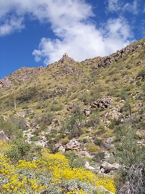


