Route Editor

| Guide | ♦ | 8 Triplogs | 3 Topics |
details | drive | no permit | forecast | 🔥 route |
stats |
photos | triplogs | topics | location |
| 97 | 8 | 3 |
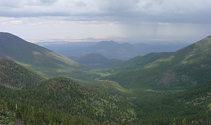
Kachina on the loose by VVebb  Overview OverviewThis is a shuttle hike of Humphreys Peak which combines two other hikes: The Humphreys Summit hike and the Humphreys via Inner Basin hike. See those descriptions for additional details. I recommend this hike if, for one reason or another, you think you might only get one chance to hike Humphreys Peak in your life -- the east and west sides of the Peaks offer unique views, and this shuttle hike gives you plenty of time to see and enjoy both sides.
This hike can be completed in either direction. When deciding which direction to do it, consider the following: - Starting at Lockett Meadow will result in a larger but more gradual elevation gain. - From Lockett Meadow will result in more sun exposure throughout the day since you'll be starting on the same side as the sunrise and finishing on the same side as the sunset. - The Snowbowl side of the mountain is more heavily traveled and likely has better cell reception, so if you think you might end up finishing your hike in the dark or otherwise getting into trouble, it might be better to start at Lockett Meadow and end at Snowbowl. Hence, you finish your hike on the safer side of the mountain. - It's going to take a while to drop off and pick up your shuttle vehicles, so be sure to think about precisely when and how you're going to accomplish this -- The most direct way might be to take Schultz Pass Road around the south edge of the mountain, but you might prefer to spend less time on dirt roads and drive through Flagstaff. Warning This area can get hit pretty hard with rain and hail during the monsoon (July-August), especially during the mid-afternoon, so rain gear is always a good idea at that time of year. Another warning to keep in mind is that during May and June following wet winters, there might still be sizable patches of snow remaining along this trail, especially on the east slope of Agassiz Peak. This can make for a treacherous span of several hundred yards of the trail if you don't have good boots and trekking poles. Hike From the Lockett Meadow Campground, hike along the Inner Basin Trail for 3.7 miles until it ends at the Weatherford Trail. Turn right and hike 2.45 miles to Humphreys Saddle, where the Weatherford Trail ends at the Humphreys Summit Trail. Then, follow the Humphreys Summit Trail for 1.0 miles to Humphreys Peak. After soaking in the views from the highest point in Arizona, turn around and hike 1.0 miles back to Humphreys Saddle. Finally, continue down the Humphreys Summit Trail toward Snowbowl for the final 4.1 miles.
Check out the Official Route and Triplogs. Note This is a more difficult hike. It would be unwise to attempt this without prior experience hiking. Leave No Trace and +Add a Triplog after your hike to support this local community. | ||||||||||||||||||||||||||||||||||||||||||||||||||||||||||||||||||||||||||||||||||||||||||||||||||||||||||||