Route Editor

| Guide | ♦ | 122 Triplogs | 17 Topics |
details | drive | no permit | forecast | 🔥 route |
stats |
photos | triplogs | topics | location |
| 946 | 122 | 17 |
Bringin' Humphreys Back by joebartels  Overview Overview3.7 miles on the Inner Basin Trail #29 to the Weatherford Trail #102. Follow the Weatherford for 2.45 miles to the Humphreys Summit Trail. 1.0 mile to the peak on the Summit Trail. Hike On likely one of the hottest Saturdays of the summer, I'd guess a hundred hiked Humphreys via the popular summit trail. The old standard is good, but please, please, don't hike a book... Hike Arizona!
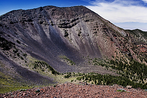
About 2.4 miles in, you enter the meadow, which most associate as "the" Inner Basin. If this is your first trip into the area, the views will bring you to a screeching halt. The dominant view is the wide scree swath on the northeast side of Fremont Peak. A little further into the meadow, nearing the pumphouse, you can make out Humphreys Peak on your right with its dark-volcanic-rock talus-slopes. A straight line between you and the peak looks daunting. Now jump back into reality. There will be switchbacks, up and downs, blood, sweat, and tears to conquer this bad boy via the not 100% shaded tree book version. Honestly, though, the tears will be of joy. The blood can be avoided with proper foot placement, and you don't sweat much at high altitude. The illusion to your conscious is "wide open meadow" = "easy hiking". And it is, of course, you're still ascending at the same 8-10% grade since you started. Move forward and enjoy the illusion until there is no doubt in your mind the Inner Basin Trail packs a punch. Just before you reach the Weatherford Trail junction, you are ascending the toughest grade on this entire hike at 23%. For reference, Camelback is a 23% average for the entire (albeit short) hike. At the Weatherford junction, your mind eases. The junction is a few feet shy of 11,000 feet. Thus far, you've conquered 2,370 feet. It's only another 1,633 feet to Humphreys Peak! Several other friendly hikers crossed paths while I was breaking at the junction. Engelmann Spruce line the trail with their dark purple male cones. The female cones are said to be found in the crown and more flexible... hmmm, Anyhow... Keep an eye out for Corkbark firs, which are similar to a Subalpine Fir yet has a lighter aspen color to it's bark. Most of them apparently die off after about 120 years due to their weak structure, making them an easy target for disease. It is the lightest American wood, weighing in at only 17 pounds per cubic foot. Luckily, all these short needle pines are soft as you will practically be wading through them in sections. Continue west 0.8 miles on the Weatherford Trail up; it's easier switchbacks to Fremont Saddle. Keep in mind this is debatably incorrectly marked Doyle Saddle on old topo maps. Apparently, this was the end of the old toll road J.W. Weatherford built back in 1926. Thankfully, the depression put that s.o.b. out of business! Some old, more likely semi-old, relics can be found in the area. This is also your last shot at nature's facilities as the tree line is near. Heading onward, a sign quickly informs you to stay on the trail as you enter the federally protected Senecio franciscanus area. It's a $500 fine if you get caught off-trail in this designated area. As you hike north on Agassiz's eastern face, vegetation gives way to the rocky slope. Heading up the big lazy "Z" switchback is almost relaxing. Personally, I find the upper section after the big switchback very intriguing. It's like being in the middle of the Superstition Ridgeline; you feel honored to be in such a magnificent setting. The terrain has subtle hues that change with the mass angles, altering upon each step you take. Certainly, timing with shadows plays a big role in this massive picture you're hiking across. Beware of bursting vocals, "oh beautiful for spacious skies!..." Remember this ain't no friggen book, sing along! Next up is Agassiz Saddle, connecting up Humphreys Summit Trail to sweet distant views. The unnerving part is when you come to a saddle only to realize you must DROP down to the real saddle. I'd venture to guess many turn around at this point, as did a couple I met on the saddle. Get over it and move on; you don't know unnerving until you've been backhanded by one of Humphreys' false summits... ugh. On this busy summer Saturday, I encountered about as many people on the summit section as the good ol' days on Piestewa Peak before freeways hit the valley. What a riot! Friendly though!!!, one guy on top greeted everybody, "welcome to the top". One gal, a dead ringer for Kelly Clarkson, puttered out, "ahh thanks!". You could feel the accomplishment through their voices. Right about then, I started thinking... these guys will be hitting the trailhead right about sun... set. Whoa, back the train up! It's seven miles to a chance to finding an open restaurant. At which point I high-tailed it outta the storybook. If going up wasn't incredible enough, I can't begin to describe going down. I'm jogging down the big switchback, thinking what more could I possibly ask for in a hike! Maybe a bear, as I've yet to encounter such, or perhaps Billy Idol will pop out of the woods. Then it came unexpectedly. The shadows casting from the setting sun were un-B-lievable with a capital U N B L I E V A B L E. I had to slow down and absorb the beauty. Photo ops seemed countless. I passed up light sequences I've practically hunted for on other hikes. Cruising down, I kept thinking to myself, "this is as good as life gets!". About a half-hour later, I come around the corner to a distant fuzzy blob. Holly cow, I'm looking at a bear. The first thing that runs through my mind is where the hell is Billy! At this point, I'm shaking. Not from fear. I'm shaking cause I don't carry a point-and-shoot camera; I have to change lenses, meter, focus... geesUS. Of course, by this point, the bear is gone and married. It didn't matter. I'd likely never see another bear, and this one wasn't gettin' away! Never mind the fact I just hiked a mountain or people aren't stupid enough to chase bears, I'm off! Of course, we couldn't go downslope, could we...ugh. The bear photos didn't pan out so well, which is fine, I guess. In hindsight, it wasn't a smart thing to do. There very well could have been a big mother bear waiting deep in the woods. Not to mention I'm sure some frown on chasing animals. Oh well, no pc versions on my parole, I tell it as it happened. I was Sooner born and Sooner bred, when I die, I'll be Sooner dead! Note Camping is not allowed in the Inner Basin
Check out the Official Route and Triplogs. Note This is a difficult hike. It would be insane to attempt this entire hike without prior experience hiking. Leave No Trace and +Add a Triplog after your hike to support this local community. | |||||||||||||||||||||||||||||||||||||||||||||||||||||||||||||||||||||||||||||||||||||||||||||||||||||||||||||||||||||||||||||||||||||||||||||||||||||||||||||||||||||||||||||||||||||||||||||||||||||||||||||||||