 Route Editor

| Guide | ♦ | 28 Triplogs | 1 Topic |
details | drive | no permit | forecast | 🔥 route |
stats |
photos | triplogs | topic | location |
| 271 | 28 | 1 |
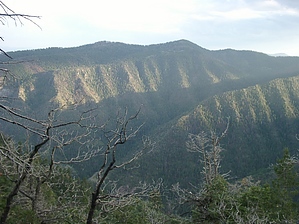
Man vs Mountain by Crocodile Ryan  This trail was an unplanned detour after a torrential downpour and about 2hours of constant bushwhacking and searching for our trail. We had planned on completing a loop of the KP rim following along the trail mentioned in KP Rim Loop, which I would say is a bit longer than is marked on that page. The trail started very well, and we had a decent map of the area from the forest service; I would recommend picking up a copy. DO NOT USE National Geographic Topos of the area; they inaccurately show the trails, we had one of these as well, and the trails were always in the wrong spot on the map. This trail was an unplanned detour after a torrential downpour and about 2hours of constant bushwhacking and searching for our trail. We had planned on completing a loop of the KP rim following along the trail mentioned in KP Rim Loop, which I would say is a bit longer than is marked on that page. The trail started very well, and we had a decent map of the area from the forest service; I would recommend picking up a copy. DO NOT USE National Geographic Topos of the area; they inaccurately show the trails, we had one of these as well, and the trails were always in the wrong spot on the map.We hiked this trail from its junction with Grant Creek to the trailhead near its junction with 315. So we hiked it in reverse, I don't think I would do in and out on this trail, too steep and too much bushwhacking, and there are too many other beautiful trails to use in the Blue Range that can be used as part of a loop.
All in all, the hike was very taxing but was a welcome shortcut during a rough trip and was a chance to hike along a seldom-used trail in a lightly used area. And I would recommend trying the hike at least once if you enjoy the area. I would recommend bringing a pair of tevas and rain gear if going. Apache - Sitgreaves FS Details Once you complete the full 13 miles of this trail you'll have an excellent idea of just how a broad diversity of habitats there are to be found on the Alpine Ranger District and the Blue Primitive Area. For the first couple of miles, this trail stays in the high country, winding its way through stands of mixed conifers and aspens. These thick stands of old-growth open regularly into beautiful, boggy little meadows called ciénegas, which are invariably aglow with wildflowers and frequently boast a small stream. Such quiet hideaways are great places to surprise a herd of grazing elk or browsing mule deer as you emerge from the quiet shadows of the trees. If you're lucky, you may even surprise one of the forest's most reclusive inhabitants, a black bear. There are few better places on the Alpine District for a close encounter of this kind. After crossing the upper reaches of the Grant Creek drainage and passing junctions with the Upper Grant Creek and Long Cienega Trails, the trail drops into Steeple Creek where the habitat changes from aspen/conifer to a riparian community of ponderosa pine, canyon hardwoods, and scattered junipers. At Mud Springs, the trail climbs out of the drainage to the south to a junction with the KP Trail. Conditions become progressively drier and warmer as the trail continues on across Steeple and KP mesas and loses elevation on its descent into the Blue. Clumps of cactus here, scattered under a pinyon and juniper overstory, make the point that you have entered a desert woodland. The trail continues on to the shady cottonwoods and picturesque rock formations of the Blue River Canyon and ends at the Blue River Road. Notes: No mechanized vehicles (including mountain bikes) permitted in Primitive Area. Water is usually available at Willow Springs, Mud Springs, and intermittent pools along Steeple Creek. Trail Log: 0.0 Steeple/Foote Creek Trailhead parking area, near Hannagan Administrative site, the trail crosses through a wood rail fence and turns to the right 1.3 Junction with Upper Grant Trail #65 in the first of four ciénegas 2.8 Junction with the Long Cienega Trail #305 3.3 Junction with KP Rim Trail #315 6.4 Junction with Paradise Trial #74 USGS Maps: Hannagan Meadow, Strayhorse, Bear Mountain Check out the Official Route and Triplogs. Note This is a more difficult hike. It would be unwise to attempt this without prior experience hiking. Leave No Trace and +Add a Triplog after your hike to support this local community. One-Way Notice This hike is listed as One-Way. When hiking several trails on a single "hike", log it with a generic name that describes the hike. Then link the trails traveled, check out the example. | |||||||||||||||||||||||||||||||||||||||||||||||||||||||||||||||||||||||||||||||||||||||||||||||||||||||||||||||||||||||||||||||||||||||||||||||||||||||||||||||||||||||||||||||||||||||||||||||||||||||||||||||||||||||||||||


