 Route Editor

| Guide | ♦ | 25 Triplogs | 0 Topics |
details | drive | no permit | forecast | route |
stats |
photos | triplogs | topics | location |
| 207 | 25 | 0 |
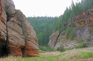
Photogenic Views by HAZ_Hikebot  Note: Ether the Official GPS Route or the mileage on this page is incorrect. Please advise... Note: Ether the Official GPS Route or the mileage on this page is incorrect. Please advise...Plentiful wildlife and great views of the San Francisco Peaks provide the significant features of interest on this section of the state-spanning Arizona Trail. For the best views, begin at the Marshall Lake Trailhead. This vital wetland, which is more of a marsh than a lake, is frequented by bald eagles in winter and osprey in summer. Waterfowl and a variety of smaller hawks are generally present year-round.
As you near Fisher Point and drop into Walnut Canyon, have your camera ready for some of the most photogenic views of the San Francisco Peaks available anywhere in the Forest. There are even some red rock cliffs here that are reminiscent of Oak Creek and the Grand Canyon. Notes: No motorized vehicles. Near Fisher Point, you'll be sharing the trail with horseback riders from a local stable. USGS Maps: Flagstaff East Marshall Lake Trailhead: Continue past Sandy's Canyon turnoff 9.2 miles to the FR 128 intersection. Turn left on FR 128 and drive 2.2 miles to the Marshall Lake trailhead. Check out the Official Route and Triplogs. Leave No Trace and +Add a Triplog after your hike to support this local community. One-Way Notice This hike is listed as One-Way. When hiking several trails on a single "hike", log it with a generic name that describes the hike. Then link the trails traveled, check out the example. | |||||||||||||||||||||||||||||||||||||||||||||||||||||||||||||||||||||||||||||||||||||||||||||||||||||||||||||||||||||||||||||||||||||||||||||||||||||||||||||||||||||||||||||||||||||||


