Schultz Creek Trail parallels one of several intermittent drainages that carry water from the higher reaches of the San Francisco Peaks. Generally, the stream only has water in it a few months of every year, either during the spring snowmelt or after a summer monsoon. However, even when there is no water here, which is most of the time, walking beside the water-smoothed stones and ledges worn by ephemeral waterfalls can still give one the pleasant feeling of being near a brook even if you have to imagine the babble.
This trail has one of the most moderate gradients on any in the San Francisco Peaks/ Mt. Elden Area. Still, it has enough ups and downs to be extremely popular with mountain bikers and off-road motorcyclists, both of whom it is open to. So, if you come for a hike or a horseback ride, keep your ears and eyes open and be ready to share the trail with users of all sorts.
When hiking several trails on a single "hike", log it with a generic name that describes the hike. Then link the trails traveled, check out the example.
WARNING! Hiking and outdoor related sports can be dangerous. Be responsible and prepare for the trip. Study the area you are entering and plan accordingly. Dress for the current and unexpected weather changes. Take plenty of water. Never go alone. Make an itinerary with your plan(s), route(s), destination(s) and expected return time. Give your itinerary to trusted family and/or friends.
Permit $$
None
Directions
Road
Paved - Car Okay
To hike 3 miles north of Flagstaff off US 180
Drive north from Flagstaff 2 miles on US 180 to FR 420 (Schultz Pass Road). Turn east and follow FR 420 about a mile to a gate and cattle guard. Turn right down over the hill toward Schultz Creek and park. The trailhead is at the north end of the parking area.
 Route Editor


 Schultz Creek Trail parallels one of several intermittent drainages that carry water from the higher reaches of the San Francisco Peaks. Generally, the stream only has water in it a few months of every year, either during the spring snowmelt or after a summer monsoon. However, even when there is no water here, which is most of the time, walking beside the water-smoothed stones and ledges worn by ephemeral waterfalls can still give one the pleasant feeling of being near a brook even if you have to imagine the babble.
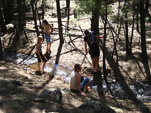


