 Route Editor

| Guide | ♦ | 52 Triplogs | 2 Topics |
details | drive | no permit | forecast | route |
stats |
photos | triplogs | topics | location |
| 441 | 52 | 2 |
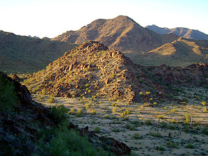
 Notice NoticeMotorized access to the east trailhead is currently not permitted, most likely due to smuggling activity. The trail itself is open and may be accessed from Margie's Cove Western Trailhead. Margies Cove Trail is a nearly level, 9-mile route through the heart of the 63,200-acre North Maricopa Mountains Wilderness. The North Maricopa Mountains are a jumble of long ridges and isolated peaks separated by extensive, saguaro-studded bajadas and wide desert washes. Cholla, ocotillo, prickly pear, paloverde, ironwood, and Mexican jumping bean complement the thick stands of saguaro to form classic Sonoran Desert vistas. Commonly seen wildlife include desert mule deer, javelina, desert bighorn sheep, coyote, desert tortoise, and numerous varieties of lizards and birds.
FACILITIES Margies Cove West Trailhead includes day-use parking for ten vehicles, three campsites with picnic tables and steel fire rings, a vault toilet, and informational signage. Margies Cove East Trailhead has day-use parking for five vehicles and informational signage. MAPS Margies Cove Trail is not mapped; however, the route is depicted on the USGS 7.5-minute topographic maps "Butterfield Pass, Ariz." and "Cotton Center SE, Ariz." The remainder of the North Maricopa Mountains Wilderness is depicted on USGS 7.5- minute topographic maps "Margies Peak, Ariz.," and Mobile NW, Ariz." NOTES
Check out the Official Route and Triplogs. Leave No Trace and +Add a Triplog after your hike to support this local community. One-Way Notice This hike is listed as One-Way. When hiking several trails on a single "hike", log it with a generic name that describes the hike. Then link the trails traveled, check out the example. | |||||||||||||||||||||||||||||||||||||||||||||||||||||||||||||||||||||||||||||||||||||||||||||||||||||||||||||||||||||||||||||||||||||||||||||||||||||||||||||||||||||||||||||||||||||||||||||||


