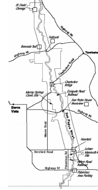
 BLM Division Details
What is Clovis?
Archaeologists named the cultural group that hunted large game in the late Ice Age after the town of Clovis, New Mexico. The first site of its type, Blackwater Draw, was discovered nearby in 1932.
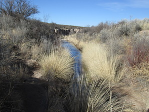
This archaeological site was named for the nearest natural feature, Murray Springs which is actually located ½ mile east. It is a desert spring; a wonderful place to see birds, but not enough water for swimming!
Artifacts of the Ice Age
The site was first discovered in 1966 by Dr. C. Vance Haynes and Dr. Peter Mehringer of the University of Arizona. Upon securing funding from the National Science Foundation and the National Geographic Society, Haynes excavated the site from 1967-1971. Many wonderful artifacts and fossil bones were found during those summers, all pieces of a great puzzle about life in the late Ice Age and the mysterious extinction of the large mammal species.
The Trail
The Murray Springs Interpretive Trail is 1/3-mile-long and offers 10 exhibits on life in the late Ice Age (Pleistocene). Thirteen thousand years ago the climate of the San Pedro was quite different. The trees and plants were more like mountain vegetation because it was cooler and wetter. Only the bones and teeth of the large Ice Age animals like mammoths, mastodons, giant ground sloths and saber-toothed cats can be found here today.
How to Get There
The trail heading east from the Murray Springs Interpretive Trail is along the abandoned Fort Huachuca to Lewis Springs railroad line. The trail is maintained for 1.8 miles, up to the intersection with the San Pedro Trail (old Del Valle Road). From there you can still follow the railroad grade east to the San Pedro River (2.2 mile). You can also hike, bike or ride south to Highway 90 and the San Pedro House (4 miles), north to the Clanton Ranch (2.3 miles) or Escapule Road (3 miles).
Some Rules – There Are Just a Few
The hike around this site is not strenuous and the hardened pathway is accessible to wheelchairs, strollers and bicycles. To keep the pathway smooth, no horses or motorized vehicles are permitted. Fossils or artifacts are protected by law – please do not pick them up or remove them. If you think you've identified an artifact or fossil, please notify BLM.
For Your Safety and Comfort
Bring adequate water for the conditions; there is a portable toilet at the site. Water and restrooms are available nearby at the San Pedro House (see map). Please pack out your own trash. Beware of snakes and other venomous animals.
One-Way NoticeThis hike is listed as One-Way.
When hiking several trails on a single "hike", log it with a generic name that describes the hike. Then link the trails traveled, check out the
example.
 Route Editor


