 Route Editor

| Guide | ♦ | 68 Triplogs | 0 Topics |
details | drive | no permit | forecast | map |
stats |
photos | triplogs | topics | location |
| 880 | 68 | 0 |
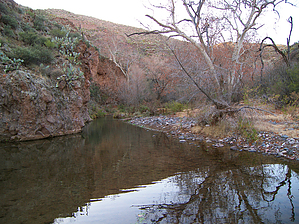
James Blunt says it best by HAZ_Hikebot   On November 28, 1990, Congress created the Gila Box Riparian National Conservation Area (RNCA) in section 201 of the Arizona Desert Wilderness Act, Public Law 101-628. As stated in the Act, the principle objective for establishing the RNCA was to "conserve, protect, and enhance" the riparian and associated values of the area. Four perennial waterways - the Gila River, Bonita Creek, Eagle Creek, and San Francisco River - are the lifeblood of this remarkable place. Not only does the RNCA hold one of the most significant riparian zones in the Southwest, but it also offers tremendous scientific, cultural, scenic, recreational, and other associated values. It is one of only two Riparian National Conservation Areas in the Nation. On November 28, 1990, Congress created the Gila Box Riparian National Conservation Area (RNCA) in section 201 of the Arizona Desert Wilderness Act, Public Law 101-628. As stated in the Act, the principle objective for establishing the RNCA was to "conserve, protect, and enhance" the riparian and associated values of the area. Four perennial waterways - the Gila River, Bonita Creek, Eagle Creek, and San Francisco River - are the lifeblood of this remarkable place. Not only does the RNCA hold one of the most significant riparian zones in the Southwest, but it also offers tremendous scientific, cultural, scenic, recreational, and other associated values. It is one of only two Riparian National Conservation Areas in the Nation.A 15-mile segment of Bonita Creek and 23 miles of the Gila River have been included in this special natural area designated by Congress. Bonita Creek, popular for birding and picnicking, is lined with large cottonwoods, sycamores, and willows, cliff dwellings, historic homesteads, Rocky Mountain bighorn sheep, and over 200 species of birds make this cool year-round desert oasis worth the short drive from Safford. The Gila River section, known as the Gila Box, is comprised of patchy mesquite woodlands, mature cottonwood trees, sandy beaches, and grand buff-colored cliffs.
River floating (inflatable kayak, canoe, raft), fishing, wildlife viewing, backpacking, camping, interpretation, and hunting. Inflatable kayak, canoe, and rafting enthusiasts take advantage of the variable water flow levels and enjoy an easy to moderate floating and camping adventure in the canyon. In the early summer, catfishing is a popular activity. Backpackers occasionally hike the canyon during the fall when the river is low enough to cross safely. A series of primitive roads provide access to various points throughout the area. Backcountry primitive camping opportunities are available at Bonita Creek and within the Gila River. A homestead cabin, rock art, and cliff dwellings show evidence of the occupation of this important perennial stream by earlier man. Today, a portion of Bonita Creek supplies the town of Safford with its municipal water. Access Bonita Creek and Gila River (West): From Safford travel approximately 5 miles east on U.S. Highway 70 to the town of Solomon and turn left onto Sanchez road. From there travel north and cross the bridge at the Gila River. Then you will drive seven more miles until you reach a Bonita Creek and Gila Box RNCA BLM sign and turn left onto that dirt road. Once on the dirt road continue traveling approximately 2.5 miles to the West entry sign of the Gila Box Riparian National Conservation Area. Boat Take Out Entry sign travel 0.5 miles to the Dry Canyon parking area on the right side of the road. Dry Canyon parking area can be used for overnight parking while on the river. Gila River (East) Take U.S. Highway 70 east of Safford for 10 miles then turn north on U.S. Highway 191. Follow the highway to milepost 160 (just 4 miles south of Clifton) and turn left onto the Black Hills Back Country Byway. Follow this graded dirt road for 4 miles to the Old Safford Bridge at the Gila River. Boat Put In The best place to put in, is on the south side of the river west of the Old Safford Bridge. For flow information you can visit USGS's website: https://waterdata.usgs.gov/nwis/rt Seasons This depends on the activity you choose, summer temperatures can be scorching, and some winter days are in the low thirties. Flash floods may occur in late summer and winter. Check out the Triplogs. Leave No Trace and +Add a Triplog after your hike to support this local community. One-Way Notice This hike is listed as One-Way. When hiking several trails on a single "hike", log it with a generic name that describes the hike. Then link the trails traveled, check out the example. | ||||||||||||||||||||||||||||||||||||||||||||||||||||||||||||||||||||


