| Guide | ♦ | 1 Triplog | 0 Topics |
details | drive | no permit | forecast | 🔥 route |
stats |
photos | triplog | topics | location |
| 25 | 1 | 0 |
Grand Views -- and a Seat to Yourself by GrangerGuy  Overview OverviewThe trail runs for 11 miles, almost the length of the wilderness from north to south along a bench between the cliffs of the Hidden Rim up to the east and the Grand Wash Cliffs down to the west, with the Grand Wash beyond. It is an easy walk with spectacular, wide-open views the whole trip. The real challenge is getting there. Hike The north end of the trail is along BLM Road 1003 in Hidden Canyon at the northeast corner of the wilderness. Just off road 1003 is the trailhead sign and a trail register, and the trail continues along a 4x4 road about 0.6 miles to the wilderness boundary and a locked gate. Park at either place.
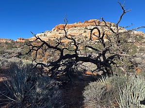
The views never stop. As you head south, the cliffs of the Hidden Rim appear on the east. The views to the west just go on and on. Although you only rarely see down into the Grand Wash itself, you can see the Cottonwood Ridge on the other side, and beyond to the Virgin Mountains and beyond. At 11.7 miles, you arrive at the gate at the southern end of the wilderness. This is a good place to turn around, or you can do the hike as a shuttle. Water Sources There is a tank about 4 miles from the north trailhead, but one would be smart to carry all the water you need for this trip. Gate Policy: If a gate is closed upon arrival, leave it closed after you go through. If it is open, leave it open. Leaving a closed gate open may put cattle in danger. Closing an open gate may cut them off from water. Please be respectful, leave gates as found. The exception is signage on the gate directing you otherwise. Check out the Official Route and Triplog. Leave No Trace and +Add a Triplog after your hike to support this local community. One-Way Notice This hike is listed as One-Way. When hiking several trails on a single "hike", log it with a generic name that describes the hike. Then link the trails traveled, check out the example. | ||||||||||||||||||||||||||||||||||||||||||||||||||||||||||||||||||||||||||||||||||||||||||||||||||||||||||||||||||||
 Route Editor


