Route Editor

| Guide | ♦ | 34 Triplogs | 0 Topics |
details | drive | permit | forecast | route |
stats |
photos | triplogs | topics | location |
| 138 | 34 | 0 |
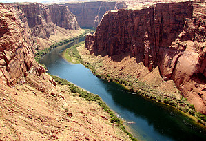
Quick view of Glen Canyon Dam by PaleoRob  The Glen Canyon Dam Overlook (sometimes called "The White House" by locals) isn't much of a hike. It's a simple down-and-back to a viewpoint on the rim of Glen Canyon. It certainly isn't a destination hike, and generally doesn't take more than 10 minutes to hike down, look at the river, and hike back. The Glen Canyon Dam Overlook (sometimes called "The White House" by locals) isn't much of a hike. It's a simple down-and-back to a viewpoint on the rim of Glen Canyon. It certainly isn't a destination hike, and generally doesn't take more than 10 minutes to hike down, look at the river, and hike back.The view, however, is spectacular. At the base of the well-marked trail is a viewing area. Directly upstream from the viewing area lays Glen Canyon Dam, one of the largest dams in the United States, and the reason for Lake Powell's existence. From this vantage point, the size of Glen Canyon Dam becomes very obvious. It's a huge concrete wedge spanning the entire width of Glen Canyon, dwarfing its power plant at its base. Depending on the time of your visit, you may see rafts being loaded up on the right-hand side of the dam. These are one-day float trips that run the remaining 18 miles of Glen Canyon from the dam down to Lee's Ferry, and provide a great way for the day visitor to experience Glen Canyon. Floaters are bussed down to the base of the dam via a 2-mile long tunnel cut through the cliff directly beneath the overlook. Built back in the late 1950s, the tunnel was built to facilitate the movement of heavy equipment from Page to the base of the dam. The tunnel starts near the Maverik gas station and is guarded to prevent unauthorized access. It is a harrowing ride through the dark, narrow, wet tunnel.
After taking in the excellent panoramic view, turn around and make the quick hike back to your car. Check out the Official Route and Triplogs. Leave No Trace and +Add a Triplog after your hike to support this local community. | |||||||||||||||||||||||||||||||||||||||||||||||||||||||||||||||||||||||||||||||||||||||||||||||||||||||||||||||||||||||||||||||||||||||||||||||||||||||||||||||||||||||||||||||||