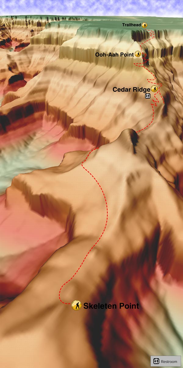
This is part of the South Kaibab Trail. It is a good day hike to Skeleton Point. There is an excellent view of the Colorado River and a hitching rail where the mules rest. This trail is used less than Bright Angel Trail for mules, so it isn't as bad. It is steeper and has no water along the trail. There is a restroom at Cedar Ridge. The trail winds down from the top with very steep switchbacks in the first 0.5 miles or so.
Then it goes out along a steep dropping canyon. There are many fossil footprints in the sandstones before Cedar Ridge in the big rocks along the trail after Ohh Ahh Point. These are mammal-like reptiles. Then the trail goes down from Cedar Ridge. In this area, there are also some plant fossils around the rest area. The trail goes off from Cedar Ridge across the flat area and keeps to the right after the restroom.
It then goes past O'Neill Butte, and there are some lovely views of Plateau Point in the east. We have done some nice full moon hikes on this trail in the early summer. Since it doesn't go down in the canyon-like Bright Angel Trail, the moon can light up the trail, and no flashlights are needed. Then along the trail from Cedar Ridge to Skeleton Point, there are many flat rocks along the area with all kinds of fossil tracks of mammal-like reptiles and spiders.
The view from Skeleton Point is incredible, and on a clear and not hazy or smoky day in the canyon can be quite colorful. You can see all the layers of the canyon from the Kaibab limestone on the top to the Vishnu Schist in the bottom of the canyon with the Colorado River. There are many times where crampons are needed in the wintertime as the trail can be quite slick with ice and snow. It is a steep trail and has very little shade, so it is not suggested to do in the summertime.
WARNING! Hiking and outdoor related sports can be dangerous. Be responsible and prepare for the trip. Study the area you are entering and plan accordingly. Dress for the current and unexpected weather changes. Take plenty of water. Never go alone. Make an itinerary with your plan(s), route(s), destination(s) and expected return time. Give your itinerary to trusted family and/or friends.
To South Kaibab Trailhead From Flagstaff head west on I-40 for 30.4 mi to SR-64. Turn right/north and follow SR-64 55 miles to the park. You will receive a map & information at the GC park entrance.
You can only reach the trailhead by free-shuttle or taxi. Parking is available at several lots. There is a lot a mile from the trailhead on the east drive. If you are there early you can use this lot (it fills up fast) and hike the two miles there and back.
Express hikers' shuttles directly from Bright Angel Lodge and the Backcountry Information Center to the South Kaibab trailhead depart daily at:
March 7:00 a.m., 8:00 a.m., and 9:00 a.m.
April 6:00 a.m., 7:00 a.m., and 8:00 a.m.
May 5:00 a.m., 6:00 a.m., and 7:00 a.m.
NPS Note: The South Kaibab Trail is located near Yaki Point. Due to the popularity of this area and extremely limited space, parking is not permitted at the trailhead. Hikers must use the park's free shuttle bus system to reach the trailhead. Every morning, several hiker express buses leave from the Bright Angel Lodge and then from the Backcountry Information Center (times vary depending on the month). Otherwise, hikers will need to take the village bus (Blue Line) to Canyon View Information Plaza and transfer to the Green Line. South Kaibab trailhead is the first stop on the Green Line.
From PHX (I-10 & AZ-51) 235 mi - about 3 hours 42 mins From TUC (Jct 1-10 & Grant) 340 mi - about 5 hours 12 mins From FLG (Jct I-17 & I-40) 88.1 mi - about 1 hour 33 mins
 Route Editor

 This is part of the South Kaibab Trail. It is a good day hike to Skeleton Point. There is an excellent view of the Colorado River and a hitching rail where the mules rest. This trail is used less than Bright Angel Trail for mules, so it isn't as bad. It is steeper and has no water along the trail. There is a restroom at Cedar Ridge. The trail winds down from the top with very steep switchbacks in the first 0.5 miles or so.
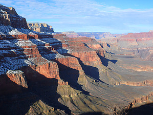


