This Tonto Trail section is primarily used as a loop from South Kaibab trailhead to Bright Angel trailhead. It is a good day hike for those in proper condition. However, it is a demanding hike because of the lack of shade from the South Kaibab trailhead to Indian Gardens. Expect little shade on the South Kaibab portion and no shade on the Tonto. Due to the extreme conditions, this hike should NOT be attempted once the temperatures reach 100 degrees. Even the fittest hikers have experienced medical problems (even death) during these conditions!
Everyone needs to carry water! A common mistake is not carrying water and not bringing enough water. When hiking in a group, each person should be carrying water; carrying for the group is a common mistake. Always remember to eat as well as drink while hiking. You will be using a lot of energy when hiking the canyon.
When hiking several trails on a single "hike", log it with a generic name that describes the hike. Then link the trails traveled, check out the example.
WARNING! Hiking and outdoor related sports can be dangerous. Be responsible and prepare for the trip. Study the area you are entering and plan accordingly. Dress for the current and unexpected weather changes. Take plenty of water. Never go alone. Make an itinerary with your plan(s), route(s), destination(s) and expected return time. Give your itinerary to trusted family and/or friends.
To South Kaibab Trailhead From Flagstaff head west on I-40 for 30.4 mi to SR-64. Turn right/north and follow SR-64 55 miles to the park. You will receive a map & information at the GC park entrance.
You can only reach the trailhead by free-shuttle or taxi. Parking is available at several lots. There is a lot a mile from the trailhead on the east drive. If you are there early you can use this lot (it fills up fast) and hike the two miles there and back.
Express hikers' shuttles directly from Bright Angel Lodge and the Backcountry Information Center to the South Kaibab trailhead depart daily at:
March 7:00 a.m., 8:00 a.m., and 9:00 a.m.
April 6:00 a.m., 7:00 a.m., and 8:00 a.m.
May 5:00 a.m., 6:00 a.m., and 7:00 a.m.
NPS Note: The South Kaibab Trail is located near Yaki Point. Due to the popularity of this area and extremely limited space, parking is not permitted at the trailhead. Hikers must use the park's free shuttle bus system to reach the trailhead. Every morning, several hiker express buses leave from the Bright Angel Lodge and then from the Backcountry Information Center (times vary depending on the month). Otherwise, hikers will need to take the village bus (Blue Line) to Canyon View Information Plaza and transfer to the Green Line. South Kaibab trailhead is the first stop on the Green Line.
From PHX (I-10 & AZ-51) 235 mi - about 3 hours 42 mins From TUC (Jct 1-10 & Grant) 340 mi - about 5 hours 12 mins From FLG (Jct I-17 & I-40) 88.1 mi - about 1 hour 33 mins
 Route Editor


 This Tonto Trail section is primarily used as a loop from South Kaibab trailhead to Bright Angel trailhead. It is a good day hike for those in proper condition. However, it is a demanding hike because of the lack of shade from the South Kaibab trailhead to Indian Gardens. Expect little shade on the South Kaibab portion and no shade on the Tonto. Due to the extreme conditions, this hike should NOT be attempted once the temperatures reach 100 degrees. Even the fittest hikers have experienced medical problems (even death) during these conditions!
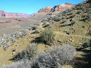


