Route Editor

| Guide | ♦ | 65 Triplogs | 2 Topics |
details | drive | permit | forecast | route |
stats |
photos | triplogs | topics | location |
| 432 | 65 | 2 |
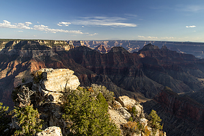
Grand Canyon Boardwalk by HAZ_Hikebot  Overview OverviewThis short trail leads southward from Grand Canyon Lodge or Bright Angel Point Trailhead. It follows the ridge that separates The Transept (west) from Roaring Springs Canyon. The route is paved and accessible to individuals using wheelchairs. It ends a half-mile from the lodge at Bright Angel Point with a spectacular perspective into Bright Angel Canyon. Experience The large tributary canyon to the east (on your left as you walk out to the point) is Roaring Springs Canyon, a major tributary to Bright Angel Creek. The main source of water for both of these drainages is Roaring Springs. Water from rain and snowmelt seeps deep into the North Rim's Kaibab Plateau, migrating gradually southward due to the southward tilt of the plateau. Channeled by fault zones, caves, and impermeable rock layers, the water emerges spectacularly from cave-sized openings in the canyon wall.
The short walk to Bright Angel Point dramatizes the effect Grand Canyon has on its surroundings. A transition from the cool green forest of the plateau to a stunted forest of pinyon and juniper on the slope occurs within a very short distance. On flat land, you would have to travel several hundred miles to experience this variation, but because of canyon topography, the transition is compressed into a few hundred yards. Warm air surges out of the canyon. Hot sun and drying winds draw moisture from soil and rock, creating inhospitable conditions for large trees. Plants that are adapted to this dynamic environment flourish, but they are shaped by its rigors. Farther out toward the point, plants give way to bare rock. The rocks appear worn and in some places precarious. Chances of the rocks giving way beneath you on any particular day are exceedingly small, yet you can feel and see agents of erosion - sun, water, and wind - slowly wearing the rock away. These forces shape the canyon every day. Will the rocks on which you stand, be here tomorrow? Probably. One thousand years from now? Maybe. Ten thousand years from now? It's not likely. A timely example of Grand Canyon's dynamic forces occurred on January 3, 1991, in The Transept, the large tributary canyon to your right as you walk out to the point. A massive section of Coconino Sandstone (the light-colored layer of rock near the top) succumbed to gravity and erosion, cascading into the canyon and trailing debris along thousands of feet of canyon wall. In 1992 similar landslides closed several major trails. The Grand Canyon area has been eroding since regional uplift began about 70 million years ago. As long as the area remains above sea level, erosion will continue. As the slide in The Transept attests, dramatic events can make a greater change in a few minutes than the cumulative changes of a century before. Someday the spot on which you are standing will be thin air. Deva, Brahma, and Zoroaster Temples to the southeast foreshadow the future of ridges like Bright Angel Peninsula. These buttes are islands of canyon wall isolated by erosion. The bridge near this trail's end is a reminder of the ultimate fate of Bright Angel Point. Check out the Official Route and Triplogs. Leave No Trace and +Add a Triplog after your hike to support this local community. | ||||||||||||||||||||||||||||||||||||||||||||||||||||||||||||||||||||||||||||||||||||||||||||||||||||||||||||||||||||||||||||||||||||||||||||||||||||||||||||||||||||||||||||||||||||||||||||||