 Route Editor

| Guide | ♦ | 2 Triplogs | 0 Topics |
details | drive | no permit | forecast | route |
stats |
photos | triplogs | topics | location |
| 116 | 2 | 0 |
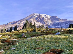
perfect by wanderingtrails Camp Muir is perched high on the south side of Mount Rainier and is the highest point you can go on the mountain without a climbing permit.
About 0.5 miles in, you’ll pass Glacier Vista, which has views of the Nisqually Glacier. From here, the grade steepens as you climb toward Pebble Creek. At roughly 2.3 miles, you reach the Pebble Creek crossing at around 7,200 feet. This is your last reliable water source (filter or treat before drinking). Once leaving Pebble Creek, you step onto the Muir Snowfield. There is no official trail. On clear days, you’ll see a steady line of hikers heading upward. On cloudy days, navigation can be tricky, so bring a GPS track or map and compass skills. The climb is steady and unrelenting, gaining about 2,800 feet over the next 2.2 miles. Early in the day, the snow can be firm, and traction devices like microspikes can help. By afternoon, expect softer, more slippery snow. Later in the season, expect multiple crevasses - the day I went was in September, and we crossed 8. Around the 8,500-foot mark, views start to open up. Looking back, you can see Mount Adams, Mount St. Helens, and Mount Hood on clear days. At about 4.2 miles from the trailhead, you’ll crest the final rise and see the stone buildings of Camp Muir. Elevation: 10,080 feet. The public shelter, built in 1921, is open for day use if you need to get out of the wind. There’s also a guide hut (private use only) and a pit toilet. The view across the way features the Cowlitz Glacier to Cathedral Gap and the Ingraham Glacier. The descent is much faster, and once you pass any crevasses, you can typically glissade down the rest of the snow. In low visibility, it’s easy to veer off course, so check your navigation. Back at Pebble Creek, you’ll rejoin the Skyline Trail and descend through the meadows. Wildflowers can be found in August and September, typically. Total time: Most hikers take 6–10 hours round-trip. Best season: Mid-July to early September for the most stable weather and minimal crevasse hazard. Permits: No climbing permit needed for day hikes to Camp Muir, but a National Park entry fee or pass is required. Check out the Official Route and Triplogs. Note This is a moderately difficult hike. Leave No Trace and +Add a Triplog after your hike to support this local community. One-Way Notice This hike is listed as One-Way. When hiking several trails on a single "hike", log it with a generic name that describes the hike. Then link the trails traveled, check out the example. | |||||||||||||||||||||||||||||||||||||||||||||||||||||||||||||||||||||||||||||||||||


