Route Editor

| Guide | ♦ | 61 Triplogs | 2 Topics |
details | drive | no permit | forecast | 🔥 route |
stats |
photos | triplogs | topics | location |
| 531 | 61 | 2 |
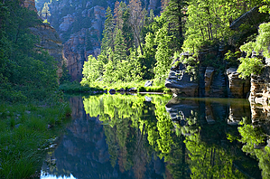
Lush creek biosphere by dabreeze  At the head of the Tramway Trail, one stands atop the Mogollon Rim some 700' above the deep & sinuous curves of West Clear Creek. The extremely steep descent to the creek below covers less than a mile over a for-the-most-part well-designed trail that alternates between switchbacks and some class 4, fall line scrambling; novice hikers beware: with a heavy pack this could be a very difficult & dangerous trail. Those with overnight gear might be better served by accessing this easternmost portion of West Clear Creek via the Maxwell Trail about a mile upstream. Maxwell has approximately the same elevation change, but over roughly twice the distance... a much gentler incline, far easier on the knees, and probably less tumble-inducing!! At the head of the Tramway Trail, one stands atop the Mogollon Rim some 700' above the deep & sinuous curves of West Clear Creek. The extremely steep descent to the creek below covers less than a mile over a for-the-most-part well-designed trail that alternates between switchbacks and some class 4, fall line scrambling; novice hikers beware: with a heavy pack this could be a very difficult & dangerous trail. Those with overnight gear might be better served by accessing this easternmost portion of West Clear Creek via the Maxwell Trail about a mile upstream. Maxwell has approximately the same elevation change, but over roughly twice the distance... a much gentler incline, far easier on the knees, and probably less tumble-inducing!!As with most of the access trails to this rugged watershed, the last couple of miles on the unmaintained jeep trails take forever. While not necessarily requiring 4x4, the second half of FR 81E and the last mile over FR 693 are nonetheless an extremely slow crawl over basalt bedrock, off-camber rutted & narrow jeep trails in which high clearance is mandatory. Any SUV will make it but count on almost a half hour to go less than two miles!!
Pools are filled with crawdads and small trout; I would surmise that this season's floods may have flushed many of the larger fish out. That's only a guess but I didn't see any edible-sized fish the entire day. In search of photographs, I ventured a mile upstream to the bottom of the Maxwell Trail & another mile and a half downstream to where a charming little spring joins the creek from the south side, under a huge canyon wall of Coconino sandstone covered with lush green flora. All in all, hiking time averaged around 2 mph but my main interest wasn't covering distance as much as discovering the light & angles. Throughout, the steep-walled canyon alternates between Kaibob limestone & Coconino sandstone. Anything but the mid-day hours throws huge portions of the canyon into deep shadow, making for contrasty & challenging photography. The creek twists and turns so a compass is useful for keeping track. While there is certainly evidence of this season's flooding (smallish debris piles; many large deadfall ponderosa pines angled downward from the rocks above), this portion of West Clear Creek seems to have suffered far less of the damage so evident further downstream (Trail 17 near Bull Pen Ranch) and in the other popular Mogollon Rim creeks (Oak, Wet Beaver, Sycamore, Secret Canyon) in this area. Coconino FS Details The trail is one of the only two maintained routes into the upper end of West Clear Creek from the north side. It is a steep trail, affording views of the creek from the rim. The trail lies within the West Clear Creek Wilderness and is closed to the use of motorized and mechanized transport (including bicycles). The trail is not suitable for horse traffic. The Tramway Trail starts at the south side of the parking area. Portions of West Clear Creek may be seen from the trail as the creek winds its way through the sinuous canyon. Good views of the various rock strata that make up the steep-walled canyon of West Clear Creek are afforded in the upper stretch of the trail. The rocks exposed near the rim are predominantly limestone laid down when the area was covered by a shallow sea. Once in the canyon, the rock type changes to sandstone, the result of deposition as sediment in an ancient ocean and by eolian (windblown) deposition. Look for the cross-bedding apparent in many of the cliff faces from this eolian deposition. Due to the southerly exposure of the trail, vegetation found on this side of the canyon consists of more heat-tolerant species such as yucca, agave, and shrub oak. Near the bottom of the canyon, these heat-tolerant plants are replaced by more typical upper riparian vegetation of Douglas-Fir, white fir, pine, oak, and ash. Growing along the creek are wild sunflowers, cattails, locust, wild grape, willows, and box elder. The trail ends at the creek but by bushwhacking it is possible to access areas downstream and upstream, including the Maxwell Trail #37.
Check out the Official Route and Triplogs. Leave No Trace and +Add a Triplog after your hike to support this local community. | ||||||||||||||||||||||||||||||||||||||||||||||||||||||||||||||||||||||||||||||||||||||||||||||||||||||||||||||||||||||||||||||||||||||||||||||||||||||||||||||||||||||||||||||||||||||||||||||||||||||||||