Route Editor

| Guide | ♦ | 4 Triplogs | 0 Topics |
details | drive | permit | forecast | map |
stats |
photos | triplogs | topics | location |
| 4 | 4 | 0 |
a private view by ck_1   Howard Smith was born in 1952 at one of the first missionary hospitals on the Navajo Reservation. He has lived in the Canyon de Chelly area all his life. In 1995 he established the Spider Rock Campground a few miles due east of Canyon de Chelly National Monument in the hope of learning about other cultures while carving out a living for himself. This wonderful man operates the rustic campground while providing a memorable experience for his guests. Howard Smith was born in 1952 at one of the first missionary hospitals on the Navajo Reservation. He has lived in the Canyon de Chelly area all his life. In 1995 he established the Spider Rock Campground a few miles due east of Canyon de Chelly National Monument in the hope of learning about other cultures while carving out a living for himself. This wonderful man operates the rustic campground while providing a memorable experience for his guests.As a result of a fellow HAZ member's suggestion, we opted to stay at Spider Rock Campground during our visit to Canyon de Chelly. The Walk Trail trailhead is located on Howard's land, making it privately owned. If you're not planning to spend the night and only want to do the hike, please check with Howard first; there could be a small fee.
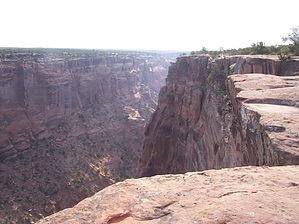
Regardless, we found ourselves hugging the rim to take in the immenseness of the canyon. As you approach the mile and a half point, the cairns seem to spread out, and a short scramble is needed to continue. Just past the 1 1/2 mile marker, the trail and canyon are closest to the nearby highway (2 lane road). The canyon eventually turns again to head north into the main canyons of the park. From this point on, there are no trail markings or cairns. After the 1-1/2 point, route-finding skills are necessary. We found the travel to be easy, as we used the canyon rim as our guide. Hiking away from the rim would present a more challenging hiking experience. The return trip was equally stunning, and we found ourselves just strolling along the hard rock surface as we checked out all the area had to offer. Just past the ruins, we noticed a small rockslide on the northeast wall of the canyon. A half dozen mule deer were working their way up what appeared to be an impassable section of the canyon wall. These sure-footed animals were amazing to watch as they leaped their way up the wall. The final 3/4 of a mile back to the trail involves most of the 220 feet of elevation gain experienced during this short hike. It was just starting to get hot when we returned to camp. Pat decided she'd relax while I prepared breakfast. This easy 3+-mile hike is a great way to explore one of the outer canyons of Canyon de Chelly National Park. It's also the only way for hikers with dogs to explore any trails in the park. The difficulty level is low, while the rewards are high. You won't find this trail listed in any hiking guide or on any map. This one is special. If you're visiting Canyon de Chelly, Howard's Walk Trail is worth exploring! Be Safe! Check out the Triplogs. Leave No Trace and +Add a Triplog after your hike to support this local community. | ||||||||||||||||||||||||||||||||||||||||||||||||||||||||||||||||||||||||||