 Route Editor

| Guide | 0 Triplogs | 0 Topics |
details | drive | permit | forecast | route |
stats |
photos | triplogs | topics | location |
| 5 | 0 | 0 |
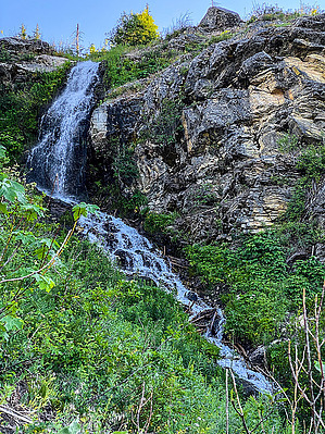
Feel the Burn by GrangerGuy The Dirty Face Trail #1500 climbs relentlessly from Lake Wenatchee to the site of a former lookout. The trail is excellent, smooth, and well-maintained. There is a pretty waterfall along the way, and the views from the summit are beautiful. This hike opens up early in the season due to the southern exposure. The Hike Dirty Face or Dirtyface? Both names are used, sometimes in the same document. The trail is clearly listed on the Forest Service web page as Dirty Face Trail, and the USGS uses Dirty Face in geologic documents.
The hike starts from a parking lot just above the Lake Wenatchee ranger station. There is a toilet at the parking lot and plenty of parking. A little picnic table in the parking lot even provides a nice space to cool down after the return trip. Upon leaving the parking lot, the trail immediately begins its relentless climb. It is never unreasonably steep but hardly ever levels out, either. Nearly 4000 feet of climb in just over 4 miles to the summit makes for the high difficulty rating, but we three 60+ hikers did the climb in 3 hours. The tread is smooth dirt almost the whole way. Those of us used to rocky Arizona trails will appreciate the smooth surface. The area is recovering from a fire in 2005, so trees continue to fall across the trail. I counted about 10 trees at the time of writing this guide, but all were easily surmounted. There were a couple of muddy spots, but overall, this is a beautiful trail. As you are climbing up through quite an elevation change, overall the flower season is long. In June, we encountered a huge variety of flowers during our climb. Snowbrush Ceanothus dominates much of the way up. But you will find beautiful Tiger Lilies and Penstemons, as well as thimbleberry in-season. As you climb, you will encounter a pretty waterfall. You switchback away from it and then eventually cross the creek above it. The trail picks up a long-abandoned road a little farther along, which has a much easier slope. With the beautiful flowers, walking this road is like walking through someone's garden. The trail follows the road for one switchback. As you depart the road, you pay the penalty for its gentleness as the trail steepens again and continues its relentless climb. The higher you get, the more impressive the views. First, Lake Wenatchee and Nason Ridge. Then Fish Lake with its algae-covered west end. Then more distant peaks of the Alpine Lakes Wilderness come into view. Finally, at the summit, you get a spectacular 360-degree view, with summits in every direction. Check out the Official Route. Note This is a difficult hike. Arrive fit and prepared or this could get ugly. Leave No Trace and +Add a Triplog after your hike to support this local community. One-Way Notice This hike is listed as One-Way. When hiking several trails on a single "hike", log it with a generic name that describes the hike. Then link the trails traveled, check out the example. | |||||||||||||||||||||||||||||||||||||||||||||||||||||||||||||||||||||||||||||||||||||||||


