 Route Editor

| Guide | ♦ | 201 Triplogs | 4 Topics |
details | drive | permit | forecast | 🔥 route |
stats |
photos | triplogs | topics | location |
| 1.4k | 201 | 4 |
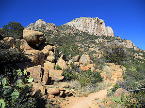
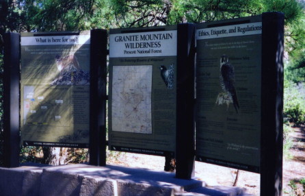
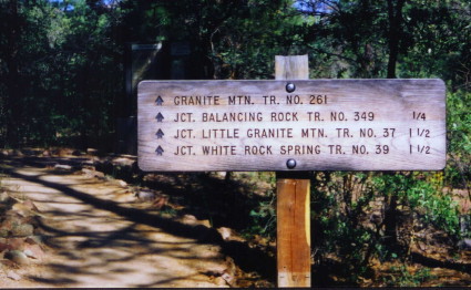
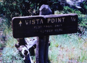
Big Boulder Bash! by Sande J  Note NoteMileage reflects data collected via GPS. The description below is going by old FS stats. If you enjoy a real rock concert, then this is a hike for you. As part of the Prescott National Forest, Granite Mountain Wilderness (appropriately named) is a picturesque area containing a little bit of everything that great Arizona hiking has to offer. The cooler temperatures and shady juniper forest make for a perfect combination of beating the heat. Heading out of Prescott on Iron Springs Rd, you will reach FR 374 at about the 3.5-mile mark, where you will make a right turn. This is a paved road for easy access to the Granite Basin day-use area. After about 3 miles on FR 374, you will see an entrance area to the small lake on your right, then continue a short distance ahead for access at the Metate Trailhead. There is ample parking with plenty of shade, including a restroom, water, and a self-pay station for the fee. The trailhead is direct across the entrance drive to the parking lot, and it is marked with a large information board. Take trail #261, Granite Mountain Trail ( not to be confused with the Little Granite Mountain Trail, which is a loop connection you will see later ), and you will get the best direct hike to Vista Point Overlook which is 3.45 miles. Just follow the #261 signs up, and you will be fine.
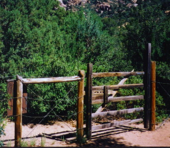
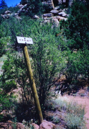
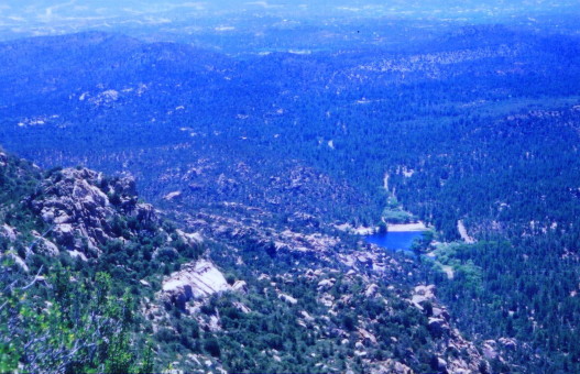
Shortly after you exit the shady section, elevation begins on well-graded and gradually ascending switchbacks. It is nice seeing all types of desert vegetation living together in harmony. Large boulders serve as guardians to the picture-perfect landscape scenery that only nature can create. I saw a few boulders that are bigger than some of the new tract homes in Phoenix. At the 1.6 mile mark, you will come to a wooden gate at Blair Saddle. Here trail # 261 intersects with the other connecting trails in the system. Here you will take a right turn to stay on #261. A sign clearly marks it. The switchbacks continue for close to a mile and the next major stop will be Granite Mountain Saddle. Here you can do one of two things, continue on the #261 to the Vista Point Overlook, or (not included in the distance above) take a quick jaunt down then up the trail to your left to get a great N/NE view of the Verde Valley, Sedona, and the San Francisco peaks. After you soak in the beauty of those views, backtrack to #261 and forge ahead .8 miles to the Vista Point which is on the S/SW side of the peak. The trek to the point offers more shady pines and some magnificent level rock slabs carpeting the ground. Coming from the valley in the summer is refreshing, as if someone turned on the air conditioning outside. Once you reach the overlook, it will put you near the vertical ledges you saw on the hike's first part. The wind gusts pick up considerably towards the overlook. Proceed with caution if your climbing urges need to be fulfilled. One big gust could knock you off stance pretty easily if you are not paying attention. From this viewpoint, you can see the lake which looks like a puddle from 7,186 ft. There are lots of huge boulders, rocks, and huge stone slabs in the area. It would be easy to spend an entire afternoon just climbing the rocks and exploring. For early June on a weekend, I was surprised to see only a few people on the trail. Have fun, and enjoy the serenity and solitude at the top. You can return the way you came on #261. This hike is fairly challenging. The quest for the summit is geared towards experienced hikers. As always, hike smart, be aware, and take plenty of water! After the adventure, turn left out of the parking lot (it is one way). You can drive around the loop road back down to the lake area for a little R & R or a picnic...sorry guys, but there is no swimming allowed! Enjoy this beautiful area, especially the CLEAN AIR. Gate Policy: If a gate is closed upon arrival, leave it closed after you go through. If it is open, leave it open. Leaving a closed gate open may put cattle in danger. Closing an open gate may cut them off from water. Please be respectful, leave gates as found. The exception is signage on the gate directing you otherwise.
Check out the Official Route and Triplogs. Leave No Trace and +Add a Triplog after your hike to support this local community. | ||||||||||||||||||||||||||||||||||||||||||||||||||||||||||||||||||||||||||||||||||||||||||||||||||||||||||||||||||||||||||||||||||||||||||||||||||||||||||||||||||||||||||||||||||||||||||||||||||||||||||||||||||||||||||||||||


