 Route Editor

| Guide | ♦ | 35 Triplogs | 2 Topics |
details | drive | no permit | forecast | 🔥 route |
stats |
photos | triplogs | topics | location |
| 523 | 35 | 2 |
A Trick in the Trail by Fritzski   Warning WarningBe advised this trail was decommissioned in 2001. The bush gods have reclaimed the forest. Travel may be difficult and painful. Hike Of the many "Rock Creek" Trails that undoubtedly exist, this one is a shady, pleasant streamside trail in the eastern Superstitions. From the Miles Trailhead, it follows Rock Creek upstream from its confluence with West Fork Pinto Creek about five miles to its end at Forest Road 650. From the parking area proceed west about 0.6mi on the West Pinto Trail (#212) past the scenic meadow and outbuildings of the old Kennedy Ranch to the intersection of the Bull Basin Trail (#270). Here you go left, taking the Bull Basin Trail southwest as it begins to follow the Rock Creek to the Rock Creek Trail intersection at about 1.3mi. There is a pleasant open area here that looks to be popular for camping and you may notice an ancient rock grave(783) next to the trunk of a large tree. Jack Carlson, the author of the excellent book "Hiker's Guide to the Superstition Wilderness", informs me that some cowboys found an anonymous body lying at that very site and just buried it where they found it.
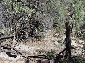
Continue along the creek bed as the trail meanders from side to side through occasional narrow slots and shady stands of sycamore trees(765) beneath the impressive and aptly named Sawtooth Ridge(766). There are several springs(773) shown on the topo map plus a few more seeps and pools along the way, but nothing too appealing as far as filterable water during a dry September. At about 2.5mi you will come across an impressive little waterfall(776) not so much due to its height (@15'), but it's very broad and straight and must be something to see when the water is flowing. At about the 3mi point, there is a bit of a "trick in the trail", so to speak. Considering myself as a somewhat wizened veteran of Superstition trails, I'm embarrassed to say I got taken in "hook, line, and sinker". Here's the devilish scenario: You're happily following the creek bed along its left bank and due to the thick tree cover you can't see the opposite bank. Unbeknownst to you (especially since you're not paying attention to minor details like a map) you run into a tributary flowing in from the left and just to make it more devious, there is a nice trail (probably created by other poor hikers suckered in like me) continuing right along the same left bank as it so gradually and innocuously veers left and heads up the tributary away from the main creek bed. The worst thing was how far I went up this thing before I finally admitted to myself that I screwed up! I'm at least a full mile up this thing when it starts to become a nasty bushwhack, but lo and behold there is a striking area of cascading bare rock pools which then I convince myself the trail was "obviously" named for, so I keep going! It was only when I topped out at a dead end in the middle of nowhere(772) that the truth became undeniable. I seem to have a definite propensity to make even the most potentially pleasant hike some kind of a "sweat and blood gruelathon". Anyhow, once back at the offending fork, it is easy to relocate the correct trail and I'm on my merry way again. From here it is more of the same with an easy-to-follow trail through nice riparian scenery(768) all the way to the 4.25mi point where the trail makes an abrupt departure out of the canyon and begins a steep climb up the bush-covered slope to its end at FR650 for about 5 miles total. Aside from some kind of a nonsensical shuttle setup, your return is merely back down the way you came. Although not a spectacular trail as far as the Supes go, this is a very pleasant hike and one to include if you enjoy the neat Miles Ranch area.
Check out the Official Route and Triplogs. Leave No Trace and +Add a Triplog after your hike to support this local community. One-Way Notice This hike is listed as One-Way. When hiking several trails on a single "hike", log it with a generic name that describes the hike. Then link the trails traveled, check out the example. | |||||||||||||||||||||||||||||||||||||||||||||||||||||||||||||||||||||||||||||||||||||||||||||||||||||||||||||||||||||||||||||||||||||||||||||||||||||||||||||||||||||||||||||||||||||||||||||||||||||||||


