 Route Editor

| Guide | ♦ | 5 Triplogs | 0 Topics |
details | drive | permit | forecast | route |
stats |
photos | triplogs | topics | location |
| 532 | 5 | 0 |
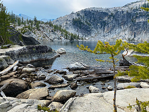
Enchanting, but challenging by GrangerGuy The Enchantment Lakes region is one of the most sought-after permits for wilderness camping in the US. It hasn’t always been that way, but it is beautiful, and in the Instagram era, the whole world knows of its beauty. Camping permits for the Lower and Upper Basins are notoriously difficult to get, requiring entering the lottery in February. The chances of winning are very low. Camping permits are required from May 15 through October 31. Day-use permits are required, but not limited. From the Snow Lakes Trailhead to the top of the Core at Aasgard Pass, on Snow Lakes Trail 1553, it is about 12.6 miles.
Access Park at the Snow Lakes Trailhead on the Icicle Road, just outside of the Bavarian town of Leavenworth. Parking here is difficult. Many people arrive overnight just to ensure a spot. Hike From the parking lot at about 1400 feet, the hike starts in the restroom end of the parking lot and immediately drops to a sturdy bridge across Icicle Creek. It then begins climbing up on a wide path, soon crossing a fast-moving canal on a low bridge. This is the beginning of a long set of switchbacks, where you gain 1000’ in 1.4 miles on an excellent trail. The trail then follows along just above Snow Creek, with an occasional switchback, crossing Snow Creek at 4.2 miles, around 4200’. The excellent trail continues to climb steadily, reaching Nada Lake, about 4950’, at about the 6-mile mark. Many people complain about how tedious these first six miles are, but I’d much rather have tedious than what comes later. Nada Lake is beautiful, and the trail along it is smooth and flat. Past the lake, the trail climbs 500’ in 1.3 miles to the dam at Snow Lake. On the way up, if you are lucky, you will see water spectacularly pouring out of a tunnel that drains Upper Snow Lake. The flow through this is adjusted at least twice a year, through a valve at the bottom of the tunnel to ensure adequate water to the Leavenworth Fish Hatchery. Once you cross the dam between upper and lower Snow Lakes, a good trail follows along the south shore of the lake for about a mile and passing many excellent campsites. Upon leaving the lake, the trail changes character completely. The trail climbs 1400’ in 1.4 miles, often over steep granite pitches, large steps that must be scrambled, and often without the benefit of switchbacks, arriving at Lake Viviane, 6800’. These pitches are difficult going up and worse going down. Lake Viviane marks the beginning of the Enchantments Core zone, and from here, it is truly beautiful. There is a fairly steep scramble from Viviane to Leprechaun Lake, and from here the way gets easier, as you walk among beautiful lake after beautiful lake. You will pass Sprite Lake, Perfection Lake, and Inspiration Lake in the lower basin, seeing many good campsites. Then there is a pretty steep scramble up to the upper basin, where you will pass several unnamed small ponds and streams, finally arriving at Isolation Lakes and Tranquil Lake, where you will find campsites. Here, the terrain could be described as a moonscape, with lakes. A short distance beyond Tranquil Lake is Aasgard Pass (officially known as Colchuck Pass, but everyone calls it Aasgard), and the end of the trail. Over the pass, and down to Colchuck Lake, is a popular but unofficial way trail, which meets up with the end of the Colchuck Lake Trail, 1599A. This allows the completion of an approximately 20-mile one-way hike between Stuart Lake / Colchuck Lake Trailhead and Snow Lakes Trailhead. Fauna There are many mountain goats in the alpine zone. These animals crave salt, especially in the early season. As a result, you should not urinate on vegetation, as this will cause them to chew the vegetation, but instead just pee on the rocks, please. They may also be interested in things like pack straps and boots, so consider where you leave these items when you are away from camp.
Check out the Official Route and Triplogs. Note This is a more difficult hike. It would be unwise to attempt this without prior experience hiking. Leave No Trace and +Add a Triplog after your hike to support this local community. One-Way Notice This hike is listed as One-Way. When hiking several trails on a single "hike", log it with a generic name that describes the hike. Then link the trails traveled, check out the example. | |||||||||||||||||||||||||||||||||||||||||||||||||||||||||||||||||||||||||||||||||||||||||||||


