 Route Editor

| Guide | ♦ | 25 Triplogs | 1 Topic |
details | drive | no permit | forecast | map |
stats |
photos | triplogs | topic | location |
| 412 | 25 | 1 |
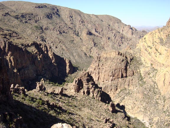
Lost Dutchman Land by Fritzski   Peter's Mesa is a rather nondescript little mountain sitting amidst many famous landmarks of the western Superstition Wilderness. This hike follows the well-worn Peters Trail (#105) from Tortilla Trailhead for nearly its entire length to the top of Peters Mesa and then off-trail to its northern end overlooking Pistol Canyon. Peter's Mesa is a rather nondescript little mountain sitting amidst many famous landmarks of the western Superstition Wilderness. This hike follows the well-worn Peters Trail (#105) from Tortilla Trailhead for nearly its entire length to the top of Peters Mesa and then off-trail to its northern end overlooking Pistol Canyon.The area is rich with Lost Dutchman lore, and the following history was graciously provided by my friend and noted expert on all things "Dutchman", Steve Creager. Steve also has several articles pending for future editions of the Superstition Mountain Historical Society Journal and you can also view many of his theories on the subject on Ron Feldman's website forum.
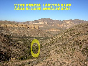
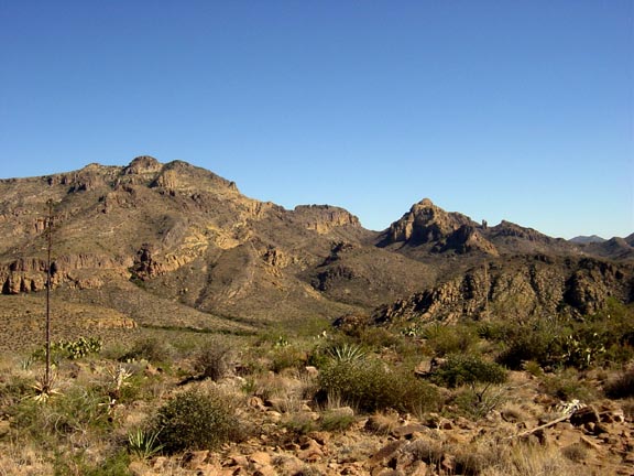
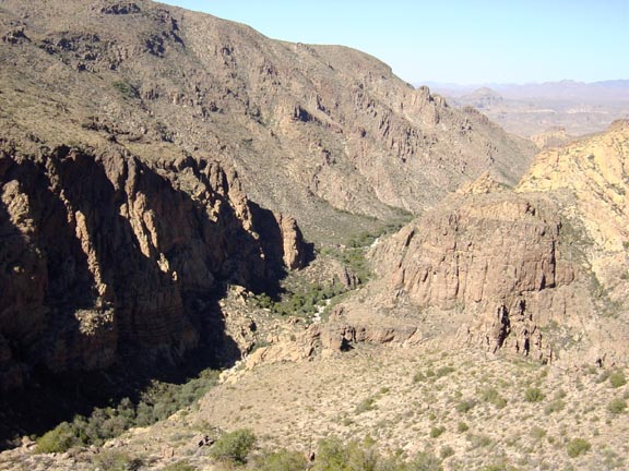
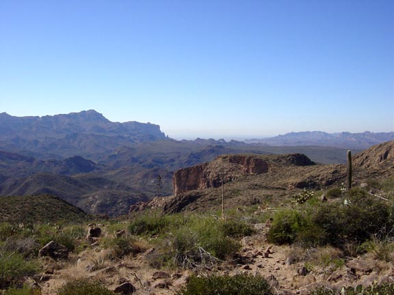
Peters Canyon and Peters Mesa were named after Old Pete - Gottfried Petrasch, father of Hermann and Rhiney Petrasch. Old Pete worked for Jim Bark for a while in the 1890s doing odd jobs. He searched - as did his sons - for the Lost Dutchman Mine off-and-on for many years following the death of Jacob Waltz. The Petrasches were one of the first groups on the scene and they covered almost the entire Superstition range in their combined searches. Pistol Canyon, neighboring Peters Mesa, received its name because in the 1920s Dutch Hunter Roy Bradford lost his pistol there. Neighboring Malapais Mountain at one time was called "Black Mountain." But over the years, the name changed. Another nearby mountain also had a different name in the past. What we now call "Black Mountain" was once known as "Charlebois Mountain." The northern section of Peters Mesa is also called Peters Dome, and sometimes "Lost Ridge." Peters Canyon, Peters Mesa, and Tortilla Mountain have been the focal point of many Dutch hunters over the years. Like other "hot spots" such as Black Top Mesa, Bluff Springs Mountain, and Upper LaBarge Box the area has seen many searchers come and go. Barry Storm, Roy Bradford, Tex Barkley, and - more recently - Crazy Jake (Robert Jacobs) all spent time in the area. None found anything of value. One of the more famous searchers who frequented the area was Walt Gassler. Gassler died of a heart attack amongst much "mystery" in the mountains near Charlebois Springs in the mid-1980s. Many have claimed to have found some interesting pre-Anglo era items in the area such as tools, sandals, and grinding stones. Similar items have also been found in other areas of the mountains. Despite the assumptions of certain Dutch Hunters, the origins of such things cannot positively be identified nor can they be used to support the notion of mining activity in any of the areas that they were found. However, such common-sense logic has never distracted searchers from investigating such areas. Hike From the old ranch ruins at the trailhead, take Peters Trail southwest where it quickly enters Tortilla Creek canyon bypassing many sheer walls and huge boulders comprised of a bizarre-looking volcanic rock. At about .75mi look for the trail to depart the creek up the right bank where you begin a gradual climb through a nice open basin. I was not able to locate either Indian Spring as depicted on the topo, but Kane Spring is easily spotted under a huge lone cottonwood standing at the bottom of the ravine you are about to climb. There was water, but its proximity to the trailhead negates any real usefulness. From the spring you begin a fairly aggressive climb to the top of Horse Ridge at about 2mi. From here you can view the trail ahead as it continues south across a peaceful grassy basin to the southernmost tip of the rugged Tortilla Mountain. I was not able to locate the old trail heading southeast as shown on the topo and described in Jack Carlson's book Hiker's Guide to the Superstition Wilderness as part of the Hoolie Bacon - Peters Loop. At about 2.75mi you come to an abrupt saddle on this tip overlooking Peters Canyon. This is a very scenic overlook with an old retaining wall on its edge looking much like a rampart. Its real purpose evades me, but there is also some old fence remains suggesting it may have somehow been for cattle. From here you begin a short, but steep descent on broken, loose rock. Treacherous going down, and a butt buster coming back up - oh well - typical Supe hiking! At 3mi you'll be at the bottom of Peters Canyon heading downstream for the next 1.3mi or so. The trail makes several crossings along the way, but is well worn and easy to follow, and pay attention to numerous cairns marking the way. The catclaw is a bit of a nuisance for a stretch, but not too bad. At about 4.3mi you come to a nice smooth rock area which makes for a nice rest spot before exiting the canyon up the left slope to the top of Peters Mesa. Once up on Peters Mesa, you'll find yourself on a very large open flat saddle with views in all directions and Black Mountain straight in front of you. At about 4.75 miles Peters Trail makes an abrupt turn south as it heads down to its intersection with the Dutchman Trail in the Charlebois Canyon area. From this point, Peters Mesa spreads out at either side with two high points, the highest being to the southeast. This hike takes you up and over the rounded northwest peak (@5.5mi) and out to a vista point overlooking Pistol Canyon (@6mi). From the point where the trail turns, begin to pick your way through the fairly clear vegetation sticking to the highest terrain. The views from the top include Squaw Canyon, Malapais Mountain, and Peters Canyon. Continuing northwest from the peak you can make your way out to a precipice at the end overlooking the rugged and interesting Pistol Canyon (not named on the topo) which is a small tributary of Peters Canyon. This is a great spot for a lunch break as you enjoy the solitude of the awesome surrounding scenery and silently wonder if you might just be unknowingly looking right at the famed Lost Mine somewhere below you. Check out the Triplogs. Leave No Trace and +Add a Triplog after your hike to support this local community. | ||||||||||||||||||||||||||||||||||||||||||||||||||||||||||||||||||||||||||||||||||||||||||


