Route Editor

| Guide | ♦ | 2 Triplogs | 0 Topics |
details | drive | no permit | forecast | route |
stats |
photos | triplogs | topics | location |
| 6 | 2 | 0 |
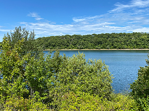
A quiet getaway by GrangerGuy This is a forested walk around Long Pond, a drinking water reservoir for Falmouth. Hike From the parking just off Gifford Street, walk right on the closed Pumping Station Road. In about a tenth of a mile, a single-track trail leaves the road to the right and heads over toward the lake where it eventually picks up a two-track again. Follow the trail counterclockwise around the lake, staying in the forest with few pond views. At every intersection, turn left, all the way around until you pass the pumping station. The best views of the lake are near the causeway between Long Pond and Grews Pond. After the pumping station, pick up Pumping Station Road, and follow it back to the parking lot.
During your hike, you may encounter hickory, birch, beech, and hornbeam. Rhododendron will provide spring color. Swimming is available at Grews Pond in Goodwill Park. Check out the Official Route and Triplogs. Leave No Trace and +Add a Triplog after your hike to support this local community. | |||||||||||||||||||||||||||||||||||||||||||||||||||||||||||||||||||||||||||||||||||||