Route Editor

| Guide | ♦ | 18 Triplogs | 0 Topics |
details | drive | permit | forecast | 🔥 route |
stats |
photos | triplogs | topics | location |
| 183 | 18 | 0 |
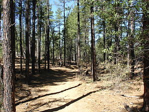
Un-Groomed Creek by BrettVet   Most people hiking in the area do the highly traveled Groom Creek trail, but just across the road is a well-traveled trail that winds down to the Hassayampa River. The trail starts across the street from the Groom Creek trailhead. The trail goes around the equine campground to the south or for a shortcut hike through the campground and take the trail entrance gate at the westernmost loop of the campground. Most people hiking in the area do the highly traveled Groom Creek trail, but just across the road is a well-traveled trail that winds down to the Hassayampa River. The trail starts across the street from the Groom Creek trailhead. The trail goes around the equine campground to the south or for a shortcut hike through the campground and take the trail entrance gate at the westernmost loop of the campground.From directly behind the campground, the first of two loops start. It is better marked by taking the trail to the northern side of the loop. This trail has a more rapid descent to the creek and allows for a more gradual ascent. The area is recently firewised, and the forest is being thinned for fire prevention. It follows the contour of the land for about a mile and ends a small connector trail to the west that connects the 383 loop you were just on the 384 loop to continue. Trail 384 uses partly 4X4 roads and trails to drop down to a forest service road at the base of the stream bed. This road passes two turn-offs to Parson's spring which will add another 2 miles to the hike if you like hiking along roads. The road also passes Hassayampa Falls, a small slot in the rock with year-round water for the most part. There are several campsites in this area.
Gate Policy: If a gate is closed upon arrival, leave it closed after you go through. If it is open, leave it open. Leaving a closed gate open may put cattle in danger. Closing an open gate may cut them off from water. Please be respectful, leave gates as found. The exception is signage on the gate directing you otherwise. Check out the Official Route and Triplogs. Leave No Trace and +Add a Triplog after your hike to support this local community. | |||||||||||||||||||||||||||||||||||||||||||||||||||||||||||||||||||||||||||||||||||||||||||||||||||||||||||||||||||||||||||||||||||||||||||||||||||||||||||||||||||||||||||||||||||||||||||||||||||||