Route Editor

| Guide | ♦ | 44 Triplogs | 2 Topics |
details | drive | no permit | forecast | map |
stats |
photos | triplogs | topics | location |
| 506 | 44 | 2 |
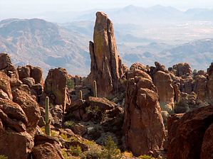
Hoodoo playground by kanode  2026 March Changes 2026 March ChangesThe Carney Spring Trailhead is closed. This hike now begins at the Lost Goldmine TH. It is 0.5 mile longer one-way and 16 feet less AEG. Pronunciation day-sight Overview The intended purpose of this page is for logging adventure hikes exploring the mesa south-southeast past Robber's Roost. My original hike took off after the false saddle. Instead of continuing up to West Boulder Saddle I went off trail and followed the ravine around to the main deck of Dacite Mesa. I headed back towards the cliffs overlooking Don's Camp. Then work back through the roost and down to Peralta. Below Kanode explains how to attain the mesa more easily and cross it quickly. You can come down to the south-southeast or explore the West Boulder-Peralta Ridge. Either is fun and can be a dangerous route-finding adventure. Be careful and go prepared. 03/09/2008 - joe West Boulder Saddle to Fremont Saddle Many hikers pass through this area while hiking from Carney Spring up to the West Boulder Saddle and then down to Fremont Saddle. However, it's a worthwhile destination on its own. From the unsigned Carney Spring parking area along Peralta road, hike 0.6 miles to a pass-through in the fence at the wilderness boundary. The trail goes up the mountain to West Boulder Saddle--it's an unofficial trail but is very well defined. . The hardest section is from the balancing "T" rock up to a false saddle. The hike from the false saddle to the top looks steep but is a surprisingly easy hike. Two-thirds of your time and effort is in getting to the false saddle. Once on top, hiking is easy if you follow cairned routes or can be difficult if you climb over rocks to take the shortest route. (Some of the cairned routes involve short sections of bushwacking and travel through tall grass. It's not a good place to be during snake season.) At West Boulder Saddle, there are well-cairned paths to both the east and west. The path going west is the Superstition Ridgeline trail. The path going NE on the south bank of the creek starts you on the path to Dacite Mesa. About 0.1 miles NE of West Boulder Saddle the cairned route crosses from the south side of the creek to the north. Note that one set of cairns heads due north and up from the crossing while another set of cairns heads east following the creek. Either route can take you to several overlooks of Fremont Saddle and Weaver's Needle. The route that heads up and north to the western edge of the yellow-streaked spire ledge is the most scenic and involves the least bushwhacking. This is the route described for the "Dacite Super Loop". It takes you to an overlook of Weaver's Needle but you'll have to head a short way back south for the overlooks of Fremont Saddle. The route that heads east along the creek offers you three more chances to head north to the overlooks of Fremont Saddle and Weaver's and also takes you towards "Robbers Roost". Note: There is a maze of cairned routes up here. If you don't know where you're headed they can lead you in interesting loops through the maze of interesting rock formations and hoodoos. See "Dacite Super Loop" and "Robbers Roost" for more info and GPS tracks. Check out the Triplogs. Leave No Trace and +Add a Triplog after your hike to support this local community. | ||||||||||||||||||||||||||||||||||||||||||||||||||||||||||||||||||||||||||||||||||||||||||||||||||||||||||||||||||||||||||||||||||||||||||||||||||||||||||||||||||||||||||||||||||||||||||||||||