 Route Editor

| Guide | ♦ | 21 Triplogs | 1 Topic |
details | drive | permit | forecast | route |
stats |
photos | triplogs | topic | location |
| 34 | 21 | 1 |
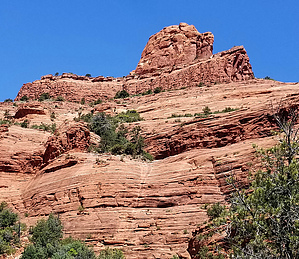
Hidden Surprises by jmzblond   This is a one-way trail that connects the trailhead at Jordan Road (trails that include Brins Mesa trail, Cibola Pass trail, and Jordan trail) to the Wilson Mountain trails. It is also a trail with some history. It was built in the 1880s by Jim Thompson as a wagon road to travel through Oak Creek to his homestead in the Indian Gardens. As it is an old wagon road, the trail is a bit wider than most and very well-defined. I encountered more mountain bikers than hikers on this trail, and that was only 4 bikers and 2 hikers. This is a one-way trail that connects the trailhead at Jordan Road (trails that include Brins Mesa trail, Cibola Pass trail, and Jordan trail) to the Wilson Mountain trails. It is also a trail with some history. It was built in the 1880s by Jim Thompson as a wagon road to travel through Oak Creek to his homestead in the Indian Gardens. As it is an old wagon road, the trail is a bit wider than most and very well-defined. I encountered more mountain bikers than hikers on this trail, and that was only 4 bikers and 2 hikers.I started at the Jordan Road trailhead after just hiking the Brins Mesa trail. I intended to see how good of a connecting trail it is to Wilson Canyon/Mountain as I didn't have any information on this specific trail. It was a beautiful December day and about 1:00 pm. The trailhead was marked and easy to find. Manzanita and pine trees line both sides of the trail. I had only hiked about a quarter of a mile when I came to a gate across the trail. On this day, the gate was open so I proceeded through. There are only slight elevation changes on this trail which open up the views all around... the city of Sedona, Thunder Mountain, Coffee Pot Rock, Chimney Rock, Mormon Valley, Steamboat Rock, etc. It's amazing the things you can see in such a short period of time. There are also many areas along this trail where it's obvious that, when water is running off the rocks above, you are walking on the top or in the middle of waterfalls. At one point, I heard a familiar trickling sound. It was faint but distinct so I ventured off trail a little and, sure enough... a little waterfall and a small creek!! Then shortly after, about a mile and a half along and just to the west of the trail, I found two rather large pools of water.
Gate Policy: If a gate is closed upon arrival, leave it closed after you go through. If it is open, leave it open. Leaving a closed gate open may put cattle in danger. Closing an open gate may cut them off from water. Please be respectful, leave gates as found. The exception is signage on the gate directing you otherwise.
Coconino FS Details This trail can be hiked from either the Wilson Canyon Trailhead (as described here) or the Jordan Road Trailhead (see map below). From Midgley Bridge parking area, start along the road past the picnic ramada. At .1 miles, bear right onto the trail marked by large rock cairns. It gradually climbs, then descends to the canyon drainage. At .6 miles, pass the fork signed for Wilson Mountain Trail and 100 yards further, take the left fork signed for Jim Thompson Trail. It immediately begins a .2 mile moderate climb. Bear right as you top out and after 100 yards, take the left fork (to the right is a path onto Steamboat Rock). The trail is wide and nearly flat with sparse shade as it follows an old road along the base of Steamboat Rock and past Steamboat Tank on the right at 1.5 miles. Nice views. At 2.25 miles, the trail passes through a cattle gate, becoming narrower and more shaded as it gently descends into Mormon Canyon. At the bottom, the trail bends right into the canyon a short way before joining the start of Brins Mesa Trail on a closed road at 3 miles. The Jordan Road Trailhead parking area is 150 yards south (left) down the road just past the gate. Return by the same route for a 6 mile roundtrip hike or hike one way in either direction with arranged transportation. Check out the Official Route and Triplogs. Leave No Trace and +Add a Triplog after your hike to support this local community. One-Way Notice This hike is listed as One-Way. When hiking several trails on a single "hike", log it with a generic name that describes the hike. Then link the trails traveled, check out the example. | ||||||||||||||||||||||||||||||||||||||||||||||||||||||||||||||||||||||||||||||||||||||||||||||||||||||||||||||||||||||||||||||||||||||||||||||||||||||||||||||||||||||||||||||||||||||||||||


