 Route Editor

| Guide | ♦ | 54 Triplogs | 0 Topics |
details | drive | permit | forecast | route |
stats |
photos | triplogs | topics | location |
| 350 | 54 | 0 |
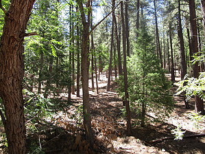
Nice when you visit Prescott by Abe   February 23rd, 2003: February 23rd, 2003:Sinful! While the east and northeast dig out of the aftermath of a large winter storm, I enjoyed a grand and glorious Sunday when I arrived at Smith Ravine, Trail # 297 in the late morning. Admittingly, I was thrown off at first looking for the trailhead, having passed a dirt road with a street sign claiming "Smith Ravine". I immediately went into react mode to turn around, fortunately, when I spied a turnoff to the right, I spied a small sign placed in the bushes stating the trailhead was there. I turned hard right into a small parking area, barely large enough to hold six vehicles. Off the beaten path on Walker Road, two things strike me about Smith Ravine. First, it is a quiet trail that caters to hikers, horse folks, and mountain bikers. And secondly, while I studied the trail, I got the feeling Smith Ravine is a popular mountain biking trail. I saw more tire tracks embedded in the ground than footprints of passing hikers.
The trail travels upward, with short brief downward jaunts. If you are lucky, as I was on this hike, you may catch a glimpse of deers running, crashing through the trees and bushes to get away from you. At certain points, you will get some awesome views to the east and the north. My favorite was the view of Mingus Mountain, the red rock country of the Verde Valley, and the San Francisco Peaks. Near the two-and-a-half-mile mark, I noted a small creek below. It was a broken creek you might say, water running above ground and then disappearing, and then coming back to the top. You could hear the slight pleasant lullaby of water running over rocks. You will know when are near the end of the trail when you spotted the Spruce Mountain lookout tower high and to your left at about 7600 feet above sea level. It is a solitary man-made structure made of iron and wood, empty during the winter. Check out the Official Route and Triplogs. Leave No Trace and +Add a Triplog after your hike to support this local community. One-Way Notice This hike is listed as One-Way. When hiking several trails on a single "hike", log it with a generic name that describes the hike. Then link the trails traveled, check out the example. | ||||||||||||||||||||||||||||||||||||||||||||||||||||||||||||||||||||||||||||||||||||||||||||||||||||||||||||||||||||||||||||||||||||||||||||||||||||||||||||||||||||||||||||||||||||||||||||


