 Route Editor

| Guide | ♦ | 46 Triplogs | 3 Topics |
details | drive | permit | forecast | route |
stats |
photos | triplogs | topics | location |
| 696 | 46 | 3 |
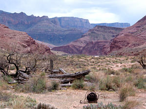
Junior Tonto Scramble by HAZ_Hikebot   History HistoryThe Little Colorado River joins the main stem of the Colorado River at river mile 61.5. Since Powell voyaged exploration in 1869, this confluence has marked the end of Marble Canyon and the formal commencement of Grand Canyon proper - the threshold of Powell's "Great Unknown." The setting is remarkable. When unstained by floodwater, the Little Colorado River is the color of the sky. Massive unbroken sweeps of vibrant vertical stone range 4000 feet up to the rim as two monumental canyon systems merge into one. The Grand Canyon is a place where the extraordinary is routine, but even here, the Beamer Trail to the mouth of the Little Colorado River represents choice canyon d'cor. The Beamer Trail was named for Ben Beamer, pioneer, farmer, and miner active in eastern Grand Canyon during the early 1890s. Beamer tried, unsuccessfully, to grow crops and live near the mouth of the Little Colorado River.
The section between the Tanner Trail and Palisades Creek offers a chance to inspect some of the oldest sedimentary rocks exposed in Grand Canyon. Known collectively as the Grand Canyon Supergroup, these colorful rocks and dark lava flows are thought to be between 800 million and 1.2 billion years old. The Supergroup is easy to spot by its distinctive 20-degree tilt. Hike Walk the Tanner Trail to the river and start upcanyon. Small outcroppings of Dox Sandstone present minor obstructions (with obvious solutions) at a couple of spots along the way. In general, the route between Tanner Canyon and Palisades Creek is straightforward. Riparian vegetation is dense near the shoreline, so the trail tends toward a line a short distance above the water where the brush starts to give way to rocky slopes. The character of the Beamer Trail changes dramatically at Palisades Canyon. A relatively easy, straight-line stroll across sandy slopes becomes a tedious, demanding trek along narrow, exposed ledges at the very brink of high cliffs. Tapeats Sandstone outcrops emerging from deep water make it impossible to stay near the river above the mouth of Palisades Creek. Climb about 300 vertical feet up the talus immediately north of the mouth of Palisades to the top of the Tapeats. This slope offers the only break in the sandstone cliff in the general vicinity, so the place to start up should be obvious. The top of the Tapeats is the route all the way to the Little Colorado. The trail is badly eroded, narrow, and, in places, remarkably exposed at the edge of an impressive precipice, so hikers should walk carefully. Hikers with a known fear of heights may find this trail segment difficult. It's almost like a junior version of the Tonto Trail, contouring around each of the many small, steep gullies that drain Palisades of the Desert. The trail is reasonably well-defined, but if there are route-finding problems, they will probably occur when the trail crosses the drainages. It is possible to scramble down to walk the shoreline 1/4 mile below the confluence, but the main trail stays on the Tapeats rim to the Little Colorado River. Water Sources The Colorado River is the only reliable source of quality drinking water. The shoreline can be accessed almost anywhere between the Tanner Trail and Palisades Creek and near the mouth of the Little Colorado River. The Colorado frequently carries a heavy sediment load and is difficult to purify under those conditions. There is permanent water in the Little Colorado's lower reaches, but the mineral or sediment content make it practically undrinkable. Campsites The Beamer Trail falls within the "at-large" use area BA9. Please use existing campsites whenever possible. There is one closed area: The mouth of the Little Colorado River represents sensitive wildlife habitat, so the area within 1/4 mile of the confluence is closed to overnight use. The best campsites are located between the Tanner Trail junction and Palisades Creek on beaches adjacent to the Colorado River. Campsite selection along the Tapeats rim between Palisades Canyon and the Little Colorado River is limited (at best) for a small party and nonexistent for a large group. Visitors camping at the Colorado River are reminded to urinate in the river. The scent of urine and associated algae growth quickly foul beaches for other hikers. Human feces should be buried 4-6 inches deep in a cat hole a minimum of 200 feet from water, camp, and trails. Carry out toilet paper and all other trash. Note If you encounter remnants of mining or other historical activities, please leave artifacts in place for other visitors to enjoy and historians to interpret. The stories of these places and people can be lost when objects are moved. Check out the Official Route and Triplogs. Leave No Trace and +Add a Triplog after your hike to support this local community. One-Way Notice This hike is listed as One-Way. When hiking several trails on a single "hike", log it with a generic name that describes the hike. Then link the trails traveled, check out the example. | ||||||||||||||||||||||||||||||||||||||||||||||||||||||||||||||||||||||||||||||||||||||||||||||||||||||||||||||||||||||||||||||||||||||||||||||||||||||||||||||||||||||||||||||||||||||||||||||||||||||||


