Route Editor

| Guide | ♦ | 135 Triplogs | 10 Topics |
details | drive | no permit | forecast | 🔥 route |
stats |
photos | triplogs | topics | location |
| 1.7k | 135 | 10 |
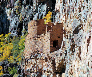
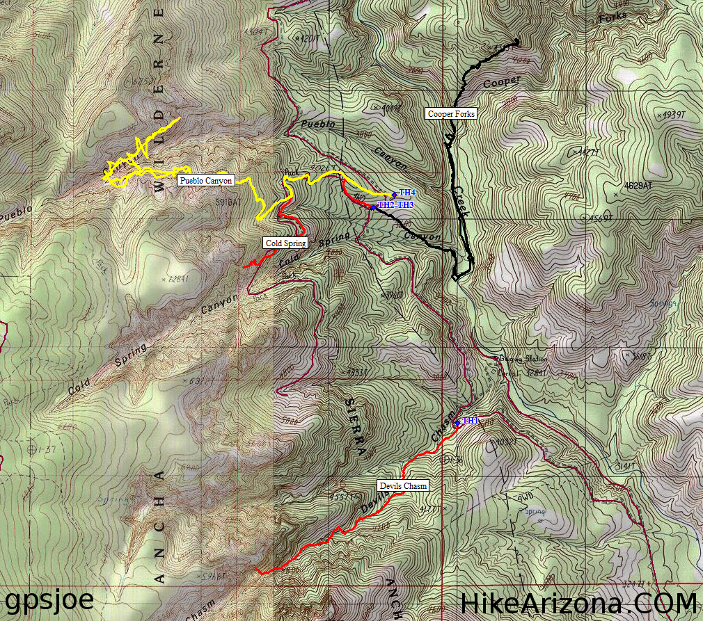
Ancha Excursion by SUN_HIKER   Devil's Chasm is a well-hidden ruin sitting secretively on a huge cliff in the Sierra Ancha Wilderness in the Tonto National Forest. We decided to do this hike in January 2003. The reason we chose the winter month is that we read in Dave Wilson's "Hiking Ruins Seldom Seen" that this area has an unusually large population of rattlesnakes. ( I recommend you get this book before setting out on this hike ) Devil's Chasm is a well-hidden ruin sitting secretively on a huge cliff in the Sierra Ancha Wilderness in the Tonto National Forest. We decided to do this hike in January 2003. The reason we chose the winter month is that we read in Dave Wilson's "Hiking Ruins Seldom Seen" that this area has an unusually large population of rattlesnakes. ( I recommend you get this book before setting out on this hike )Because the days are short in January you will have to start early and dress warmly as we found out it was quite cold. Most of the trail is in the woods, so not too much sunlight will reach the trail. You also should have a four-wheel drive vehicle to maneuver the last couple of miles that take you over some pretty rough and rocky dirt roads to the trailhead. Although the trail is only 3 miles round trip it seemed to be one of the most treacherous hikes we did.
After the waterfall, we maneuvered our way across a thin cliff that proved to be a bit unnerving for one hiker who decided to wait for our return back to this point. Shortly after the cliff, we came across a second waterfall. We all had lunch here while trying to figure out where the trail continued. This proved to be sheer guesswork, because from then on you could not tell which way to go. We were climbing, crawling, and hanging on to prevent sliding down on the loose steep ground. You will want to bring your hiking pole to keep your footing. Steady yourself with one pole and use the other hand to grab onto anything you can. The ruin will be located on a huge cliff to your right, appearing out of nowhere. It can't be seen until you get close to it. We spent a long time at the ruin in awe of its remains. If you look closely you can still see the mud-hardened handprints left by the Indians on some of the inside walls. Looking out from the ruins, the scenery was spectacular. Suddenly we realized that we would now have to carefully maneuver our way back down without breaking our necks! It took a while. When we came across the waterfall it appeared to be much more difficult to climb down than on our way up, mostly because by then we were all exhausted and cold. We did however have enough strength to stop on our way home in Miami at a wonderful Mexican Restaurant called Guayo's El Rey at 716 Sullivan MIAMI, AZ. (I highly recommend that if you do the trip, take the time to enjoy the food at the restaurant.)
Check out the Official Route and Triplogs. Note This is a moderately difficult hike. Leave No Trace and +Add a Triplog after your hike to support this local community. | ||||||||||||||||||||||||||||||||||||||||||||||||||||||||||||||||||||||||||||||||||||||||||||||||||||||||||||||