Route Editor

| Guide | ♦ | 42 Triplogs | 0 Topics |
details | drive | no permit | forecast | route |
stats |
photos | triplogs | topics | location |
| 71 | 42 | 0 |
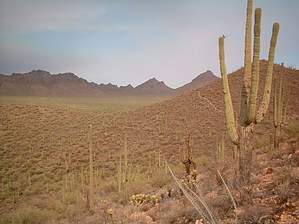
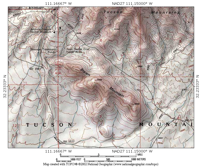
Sonoran Desert Sampler by Lizard  Note NoteThe Official Route starts from the Brown Mountain Trailhead on the flip SE side vs NE approach described below from Juan Santa Cruz Picnic Area. It should be easy to figure out the 200 ft access if you prefer starting from the Picnic Area. Prologue Brown Mountain is the aptly-named peak that dominates views from the Arizona-Sonora Desert Museum. The trail that follows its ridgeline is not incredibly scenic or challenging compared to other Tucson area hikes. However, it does have its charms. Like most ridgeline hikes, it offers good views and lovely spots to watch the sunset. This trail also provides a good sampling of Sonoran Desert flora and fauna. You may see, as I did, a coyote run across the road or be able to look down on the speckled back of a hawk as it glides on currents of air below you.
To the south of the parking area, look across the drainage to locate a trail heading up Brown Mountain. Dropdown across the drainage and follow this trail up. It switchbacks gently up the peak, passing a trail sign indicating this trail goes to the Gilbert Ray campground. It climbs gently higher, traversing around under the actual summit of Brown Mountain. You can scramble up to the top of this peak, but better views can be found further south by merely following the trail. The trail drops into a saddle, then climbs gently again up the second peak on the ridgeline. You will quickly gain the shoulder of this peak, and then on the southwest side of the peak, the trail climbs out onto the actual ridgeline. The next 3/4 mile is the best of this hike. As the trail follows the ridgeline, you are treated to great views of Golden Gate Mountain and Wasson Peak, Saguaro National Park West, Avra Valley, and Baboquivari and Kitt Peaks off in the distance. Near the end of the ridgeline, the trail passes a flat bench. This flat area is a great spot to sit and watch the sun sink behind the far off mountains. The trail drops quickly off the mountain and into a drainage. You meet a junction with a trail heading to Gilbert Ray Campground in this drainage, where you will want to bear left on the trail signed "Cougar Trail." This trail heads across the desert, weaving among typical Sonoran Desert fauna like saguaros, prickly pears, and creosote. Bear left at all unmarked junctions, and you will eventually reach paved Kinney Road. Cross this road and go through the gate. Turn left here, onto a wide dirt road that parallels the paved road. This road will lead you off into the desert to meet an access road underneath some power lines. Turn left onto this access road, and follow it along under the buzzing powerlines. After climbing to the top of a low ridge, you will gain a view of a wash filled with construction debris and the Desert Museum beyond. Drop down to this wash, where you will turn left, away from the power lines, and head south towards Kinney Road. Once you reach the road, turn right and follow it a short distance to Juan Santa Cruz Picnic Grounds' entrance. Gate Policy: If a gate is closed upon arrival, leave it closed after you go through. If it is open, leave it open. Leaving a closed gate open may put cattle in danger. Closing an open gate may cut them off from water. Please be respectful, leave gates as found. The exception is signage on the gate directing you otherwise.
Check out the Official Route and Triplogs. Leave No Trace and +Add a Triplog after your hike to support this local community. | |||||||||||||||||||||||||||||||||||||||||||||||||||||||||||||||||||||||||||||||||||||||||||||||||||||||||||||||||||||||||||||||||||||||||||||||||||||||||||||||||||||||||||||||||||||||||||||