Route Editor

| Guide | ♦ | 25 Triplogs | 1 Topic |
details | drive | no permit | forecast | 🔥 route |
stats |
photos | triplogs | topic | location |
| 223 | 25 | 1 |
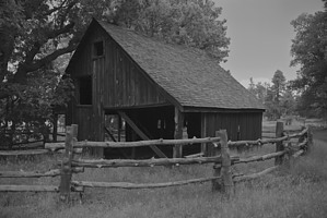
the hunt for blue by jmangum  Los Burros Trail #631 is in the White Mountain Trail System. The USFS classifies this trail as a light use trail, and I would have to agree. It is a popular mountain biking trail in the area and is also open to horses. The day I was on it, I saw one party each. The trail starts at the Los Burros campground, once the site of the Los Burros Ranger Station. Two of the original buildings still stand. The campground has a nice map of the trail on the information board. With a total elevation gain of only 500', it's not challenging. Make sure to take a look at the map before you head off. Los Burros Trail #631 is in the White Mountain Trail System. The USFS classifies this trail as a light use trail, and I would have to agree. It is a popular mountain biking trail in the area and is also open to horses. The day I was on it, I saw one party each. The trail starts at the Los Burros campground, once the site of the Los Burros Ranger Station. Two of the original buildings still stand. The campground has a nice map of the trail on the information board. With a total elevation gain of only 500', it's not challenging. Make sure to take a look at the map before you head off.From the Campground, you will go a short 0.2 miles to the gate. After the gate, you find yourself on the power line maintenance road. Since this hike is a loop, you can do turn either left or right. I chose to turn right and hike the trail counterclockwise.
The trail winds through aspen groves and stands of old-growth ponderosa pines with a carpet of knee-high ferns. After about 3 1/2 miles, the trail makes the only real significant climb, a steady up for about a mile or so. Continue on the trail following the blue tags on the trees. At about mile 5 there is a spilt in the trail with markers pointing you in two different directions. Take a left (following the blue tags with yellow dots), and you will cut back to the campground for a total of 8 miles. If you turn right (following the blue tags without dots), you will hike the entire 14 miles. This way takes you up and around Wishbone Mountain. If you take the long loop and go the entire 14 miles, you will cross the power line road once and the main road twice before ending back on the power line road to complete the whole loop. The key is to find the blue tags. If you follow the blue tags, it is impossible to get lost. This is the first time I hiked this trail - next time, I will bring my camera. It is absolutely amazing. Gate Policy: If a gate is closed upon arrival, leave it closed after you go through. If it is open, leave it open. Leaving a closed gate open may put cattle in danger. Closing an open gate may cut them off from water. Please be respectful, leave gates as found. The exception is signage on the gate directing you otherwise. Check out the Official Route and Triplogs. Leave No Trace and +Add a Triplog after your hike to support this local community. | ||||||||||||||||||||||||||||||||||||||||||||||||||||||||||||||||||||||||||||||||||