The Quartz trail and its fellow connected trails form the beginning of the planned McDowell Sonoran Preserve hiking system.
The trail itself follows a wash through the McDowell Mountain Ranch development for about two miles before entering the actual preserve. These two miles aren't of particular interest, and homes are almost always visible nearby. But it is quiet and not heavily used.
Once out of the neighborhood there a variety of options are available, including a short hike to the Taliesin overlook, a short strenuous climb to a quartz outcropping, and a hike that leads into the McDowells.
The hike into the McDowells is of the most interest to me, as it leads out of civilization and into the heart of the southern McDowells. It's the same direction as the quartz climb, just take left turns at the two intersections and you should end up heading north. Once past the path leading up to the quartz outcropping, the trail continues around the quartz mountain into the McDowells. Great views of Thompson peak (the peak is less than a mile away at times), pure serenity, and thick vegetation make this the payoff for me. The trail follows a large open wash that twists and turns near the end. The trail ends at a rock waterfall that's about 10 feet high. There isn't a trail beyond that point and I don't recommend bushwhacking further on (Sonoran Preserve rules prevent that).
As for difficulty, it's pretty easy. It is a steady climb until you turn around, and if you combine the Taliesin overlook with the quartz climb then you add several hundred more feet to the elevation change for more difficulty.
The trails are suited for mountain biking and trail running; most people on the trails are doing those activities.
I recommend this trail near sunset and on cloudy days when rain is threatening. There's nothing like watching the low-lying clouds roll over and conceal the peaks and fill in the valleys.
The map in the images doesn't show the full distance the trail goes back.
When hiking several trails on a single "hike", log it with a generic name that describes the hike. Then link the trails traveled, check out the example.
WARNING! Hiking and outdoor related sports can be dangerous. Be responsible and prepare for the trip. Study the area you are entering and plan accordingly. Dress for the current and unexpected weather changes. Take plenty of water. Never go alone. Make an itinerary with your plan(s), route(s), destination(s) and expected return time. Give your itinerary to trusted family and/or friends.
Permit $$
None
Directions
Road
Paved - Car Okay
To hike 101 to Frank Lloyd Wright (FLW), east on FLW. North on Thompson Peak Parkway. East on McDowell Mountain Ranch. Hang a right onto 104th and pull into the parking lot (SW corner of 104th and McDowell Mountain Ranch). Cross 104th, heading south, follow the sign to the trail. Hang a left to take the trail towards the McDowells.
 Route Editor

 The Quartz trail and its fellow connected trails form the beginning of the planned McDowell Sonoran Preserve hiking system.
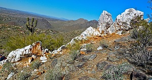


