 Route Editor

| Guide | ♦ | 91 Triplogs | 1 Topic |
details | drive | no permit | forecast | 🔥 route |
stats |
photos | triplogs | topic | location |
| 1.2k | 91 | 1 |
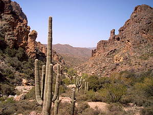
Day hike or backpack by whereveriroam   The Hoolie Bacon is a trail that gets little use in what I would call the heart of the Superstitions. It's a trail that isn't easily accessible and one must walk miles to access either end of it. People willing to put their 4X4 to the test can get within 3/4's of a mile of the northern end of the trail by driving up FR 213 off the Apache trail (AZ 88). Even though we parked just off the Apache trail at the lower Tortilla TH and hiked in the 3.2 miles of FR 213 we were able to do this trail to its end as a day hike in February. The end is at the intersection of Red Tanks trail #107, round trip it's 16.6 miles / 2400 aeg. The Hoolie Bacon is a trail that gets little use in what I would call the heart of the Superstitions. It's a trail that isn't easily accessible and one must walk miles to access either end of it. People willing to put their 4X4 to the test can get within 3/4's of a mile of the northern end of the trail by driving up FR 213 off the Apache trail (AZ 88). Even though we parked just off the Apache trail at the lower Tortilla TH and hiked in the 3.2 miles of FR 213 we were able to do this trail to its end as a day hike in February. The end is at the intersection of Red Tanks trail #107, round trip it's 16.6 miles / 2400 aeg.SR88 to Tortilla Trailhead I'll describe this hike from the lower TH since most people will opt to start from there. From the parking lot head south up FR 213, for those of you wondering it's only the 1st 1/8th of a mile of this road that makes it inaccessible for most vehicles. You'll hike this scenic road gradually climbing 300'- 400'in elevation gain to a gated pass, which overlooks the old ranch site. Along the way, you'll have great views into Tortilla Creek and Tortilla Mtn. which will be to your right (west). On the east side, you'll get some views into some of the feeder canyons that drain into Fish Creek. You'll then have to descend 100'- 200' gradually to the ranch area passing the old remains of this ranch. Continue along this road after the ranch to its end heading SE to the Wilderness boundary. Prior to the roads end off to your right will be an old tank and windmill, which marks the area where Peter's trail #105 lies next to Tortilla Creek, ignore that.
From this wilderness boundary hike up to the SE on this rocky hill, which is the beginning of the JF trail #106 which I believe, is not signed. If you haven't noticed already as you hike up this hill then turn around and look to the NW and you can see the ranch pass you came in from. More impressively is the view to the NE and N as you'll see some awesome-looking rock-walled canyons and mountains. As you continue up the hillside about 3/4's of a mile from the wilderness boundary you'll reach the signed intersection of the Hoolie Bacon and JF trails, you'll have gained about 200'. Go right onto Hoolie. Hoolie Bacon Trail You'll then stay pretty level for the next few minutes before you'll have to drop into Tortilla Creek, which you haven't seen since you left the ranch area. Once in the creek watch for cairns, as you head into the small canyon, I believe you'll cross the creek twice prior to emerging from this canyon. Once out of the canyon the area opens up and there's an excellent camping spot. Pay attention here since Tortilla creek will head off to the SE but the trail you're on heads off to the SW crossing the creek a 3rd time. Shortly after crossing the creek, as you head up you'll soon see a large old horse trough to your left, I believe Nighthawk spring is in the hills above it. The next part of the hike was in my opinion the hardest as you climb up Horse Ridge. It's only about a 600' gain or so but I remember a couple of tough switchbacks as well as a false summit. Once on top of Horse Ridge stop and enjoy the view, you'll be about 1/2 way on the actual Hoolie trail. Look back at the way you just came and glance to the ridgeline on the opposite side of Tortilla creek and you'll see parts of the JF trail. When you study the terrain to your south you'll see Herman Mtn. in the distance, which is in the area of your destination. In back of Herman Mtn. is the massive Coffee Flat Mtn. and the entrance to Upper LaBarge Box lies between the 2 of them. Another landmark is just to the SW and that's Music Mtn. Now, remember that 600' you gained? Well, it's time to give most of that back as you descend into Horse Basin. As we descended we couldn't help but notice all the century stalks lying around like matchsticks. They look as though they've been down for some time but we figured that one heck of a microburst blew thru here at one time. As you continue to descend you can see your trail as it heads off to a small hill in the near distance. Before you reach this hill if you look off to your right (NW) you'll see an old corral, it's a minor bushwhack to it if you want to check it out. This whole area around here looks like worth checking out at a later date, off to the west is the shortcut to Peter's Trail, and to the east a small wooded area. From what we've heard and read about this trail we had expected to have some difficulty finding it in places as well as getting cut up from catclaw. The only difficult part finding the trail we experienced was descending off this small hill and into the drainage that feeds Trap Canyon. There's a hidden switchback about 1/2 down that cuts to your right, we built a cairn there so you shouldn't have any problem. Near the drainage at the bottom of the hill is another good camping spot for you backpackers. From here the trail follows the drainage SE crossing it 3 or 5 times before leaving it as the creek enters Trap Canyon. This part along the creek is overgrown and can cut you up but it's short and the trail is definable. (As you pass the Trap Canyon mouth it looks passable and is supposedly a shortcut into Upper LaBarge Box but it looks overgrown). Now that you're out of the drainage and licking your fresh wounds you'll have about 150' climb up to a small saddle before your final descent to the Red Tanks trail. As you climb up and then down from this saddle Herman Mtn. is just off to your right so if you have any ill feelings that you're getting lost remember that. The trail is definable as you make your final 300' drop to the eastern entrance of Upper LaBarge box at the intersection of Red Tanks Trail. Although we didn't find the gold we did find this to be an interesting although waterless trail when we did this trip. It would serve well as part of a future backpacking loop and is the area where the Superstitions transition from the massive blocks of rock of the western end to the rolling hills of the central part of the wilderness. Gate Policy: If a gate is closed upon arrival, leave it closed after you go through. If it is open, leave it open. Leaving a closed gate open may put cattle in danger. Closing an open gate may cut them off from water. Please be respectful, leave gates as found. The exception is signage on the gate directing you otherwise. Check out the Official Route and Triplogs. Leave No Trace and +Add a Triplog after your hike to support this local community. One-Way Notice This hike is listed as One-Way. When hiking several trails on a single "hike", log it with a generic name that describes the hike. Then link the trails traveled, check out the example. | |||||||||||||||||||||||||||||||||||||||||||||||||||||||||||||||||||||||||||||||||||||||||||||||||||||||||||||||||||||||||||||||||||||||||||||||||||||||||||||||||||||||||||||||||||||||||||||||||||||||||||||


