 Route Editor

| Guide | ♦ | 52 Triplogs | 1 Topic |
details | drive | no permit | forecast | map |
stats |
photos | triplogs | topic | location |
| 234 | 52 | 1 |
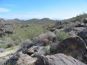
moderate (for distance) by Randal_Schulhauser  National Trail from Telegraph Pass to Pima Canyon National Trail from Telegraph Pass to Pima CanyonIf you are looking for a full-day challenge, combine this hike with Telegraph Pass and Desert Classic to make an 18 mile loop. Cosmic Ray has labeled this a "primo fat tire trail", but there is plenty of room to share with hikers, dogs, and horses. South Mountain is purportedly the world's largest municipal park... but it's also a preserve. Typical Sonoran desert vegetation abounds. Evidence of ancient volcanic activity is everywhere. There are petroglyphs scattered along the trail, particularly near the junction of Hidden Valley Trail or Marcos DeNiza Inscription Rock at the Pima Canyon trailhead. Don't let the distance discourage you. There are numerous side trails with loop-backs allowing one to customize their hike to suit their own personal wants and needs. I'll describe a recent "west to east" complete National Trail East hike; Mile 0.0 From the Telegraph Pass saddle, take the trail marked "National Trail East". Follow the switchbacks up the ridgeline. You have views of Ahwatukee and Gila River Indian Reservation to the south and downtown Phoenix to the north. Trail also looks down on Summit Road. Mile 2.2 At trail post #25, take east fork (right) towards Summit Road. Mile 2.3 Cross Summit Road. You will pick up the National Trail at trail post #23 and continue east. Mile 3.1 At trail post #21, continue east (left) downhill and enter the Buena Vista parking lot. This serves as a popular trailhead for many hikers. Mile 3.4 At trail post #18, continue east (left). Mile 4.8 At trail post #13, head south (left) to continue on the National Trail. East fork (right) is Hidden Valley Trail. It is a recommended option to take the Hidden Valley Trail as it will loop back to the National Trail and provide some of the most interesting scenery on South Mountain. Fat Man's Pass, the Tunnel, and many mushroom rocks are my personal favorites. Mile 5.3 At trail post #10, head east (right). South fork (left) is the Mormon Loop Trail. Mile 5.4 At trail post #9, head east (left). Side trail to south is Hidden Valley Trail. Mile 6.7 At trail post #2, stay south (right). Side trail to the left is the Mormon Loop Trail. Mile 6.8 Climb down into Pima wash and join onto the dirt road. There are ramadas and benches if you need to rest. Continue along the dirt road to the Pima Canyon trailhead and parking lot. Mile 7.4 Beverly Canyon Trail intersects dirt road. Have the option to head south (right) to climb up and over to Desert Classic Trail if taking the return loop. Otherwise, continue along the dirt road to the Pima Canyon trailhead. Mile 8.1 Marcos de Niza ramadas at trailhead have water and washrooms available. End your hike here or pick up the Desert Classic Trail at the south side of the parking lot.
Check out the Triplogs. Leave No Trace and +Add a Triplog after your hike to support this local community. One-Way Notice This hike is listed as One-Way. When hiking several trails on a single "hike", log it with a generic name that describes the hike. Then link the trails traveled, check out the example. | |||||||||||||||||||||||||||||||||||||||||||||||||||||||||||||||||||||||||||||||||||||||||||||||||||||||||||||||||||||||||||||||||||||||||||||||||||||||||||||||||||||||||||||||||||


