If you are looking for a high-yield day trip with low dues to pay, this is the one. Excellent trail condition, expansive vistas, and next to zero commute combine to offer you almost everything you hike for. Almost. If it is isolation and vistas untarnished by humanity you seek, read no further.
My wife and a friend were attending a conference in Tucson for the week in late May '04 and wanted a "nice reasonable day hike". It had to be squeezed in amongst the meetings and I am sure the Chamber of Commerce arranged for attendees to have Tuesday afternoon off to be tourists ( spend money ). I got my companions to leave their meeting early and we got to the trailhead by 11:00. Since that was their decision to start late, I had told them hiking in the hottest part of the day adds to the experience. Wasn't so bad actually.
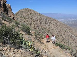
The trailhead is very easy to find and has lots of parking. The Hugh Norris Trail is best described as a Sonoran desert ridge hike to a peak ( Wasson ). Some mining had occurred prior to the area being elevated to National Monument status, but very little is disturbed. It seemed that very few people ever stray from the trail except to approach vistas just off the trail. The trail starts through the rolling desert up a broad canyon but shortly gains much of its elevation in switchbacks up onto the ridge. Saguaro, Ocotillo, cholla, and other cactus species are plentiful and one can easily see throughout the hike, the changes in species ratios as environmental conditions ( steeper slope, northern face, etc. ) change. Once on the ridge, the trail follows one side or the other winding between minor peaks but always with amazingly different vistas. About three miles out you will reach a junction with the Sendero Esperanza Trail. If you are not handling the heat/exercise well, this would be a good turnaround point, for ahead is a considerable climb up to a saddle by Anole Peak. The views only get better. Being unfamiliar with the area, I could not tell which peak was Wasson, but I do not think you can see it until you climb a series of steep switchbacks where the trail splits. The trail to the left climbs the very visible Wasson Peak ( 4687' ) from which you will have a complete panoramic view which includes the Catalinas, the Rincons, and Baboquivari. What a payoff!
On the way back, the other trail, now to the left at the split, descends along a north-facing ridge and passes an old mine shaft visible from the trail up Wasson. My companions insisted on a look. (HAZ does not recommend exploring any mine shafts as people have been seriously hurt in the attempt.) Of course, the 'veteran' ( me ) was required to test the 8' climb down to the rubble floor. I found no instability, no horizontal tunnels, no snakes. I used a stick to wake up any sleeping rattlers before I descended, but I make no promises to the next person. Like many trails, the views back down the trail are different in the late afternoon light and well worth pausing for. All things considered, even though I only get to AZ once every few years, I *will* make it back to this gem.
WARNING! Hiking and outdoor related sports can be dangerous. Be responsible and prepare for the trip. Study the area you are entering and plan accordingly. Dress for the current and unexpected weather changes. Take plenty of water. Never go alone. Make an itinerary with your plan(s), route(s), destination(s) and expected return time. Give your itinerary to trusted family and/or friends.
Permit $$
None
Saguaro National Park 2022 $25 vehicle • $20 motorcycle • $15 individual on foot or bicycle
Receipt is valid for 7 days
$45 Annual Park Pass View All
No fee required from Miller Creek Trailhead off Mescal Rd.
Directions
Road
Paved - Car Okay
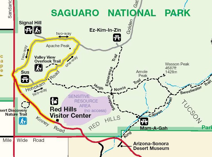
To hike Out of Tucson, take either Speedway Blvd. or Ajo Way and turn onto Kinney Road north. Look for signs for the Saguaro NM, Red Hills Information Center and continue 1.5 miles beyond it and turn right on Bajada Loop Rd. The trailhead is about a mile further.
 Route Editor

 If you are looking for a high-yield day trip with low dues to pay, this is the one. Excellent trail condition, expansive vistas, and next to zero commute combine to offer you almost everything you hike for. Almost. If it is isolation and vistas untarnished by humanity you seek, read no further.