Route Editor

| Guide | ♦ | 147 Triplogs | 5 Topics |
details | drive | no permit | forecast | 🔥 route |
stats |
photos | triplogs | topics | location |
| 2k | 147 | 5 |
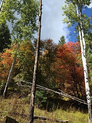
Fall Color wonderland by aaronhales   History HistoryGlenn Reynolds built the first house on this creek. For many years he was a prominent Gila County cattleman. In 1888 he was elected sheriff of Gila County. On November 2nd, 1889, he was escorting Apache prisoners and killed by the Apache Kid. Note Stay to the left at the parking area, and ignore the road/trail that continues to the right. If you have not crossed the split-log bridge(2026 Update: long gone) in the first minute or two of your hike, you are on the wrong trail!
For the past few months, I had been planning to get around to hiking Reynolds Creek, but after seeing it as the "Hike of the Month" in a recent Arizona Highways, that was the final straw. Now I HAD to go. Hike This hike starts at the terminus of FR 410 off HWY 288. At 6000+ft in elevation and being in a nicely shaded canyon, the ponderosas are plentiful and big. I started at about 7:45, and after about 5 minutes of hiking, I heard some rustling in the brush down below and saw three black bears, a mother, and her cubs, much to my surprise. They immediately headed to the other side of the canyon and into the woods. I treaded a bit more cautiously after that to make sure I didn't run into any more bears. The trail heads east along the north face of the canyon, passing Reynolds Creek Falls. It was no more than a trickle when I was there, but they are about 50 feet in height and would be quite impressive after snowmelt or heavy rain. Eventually, the trail crosses the creek and heads southeast towards Aztec Peak. At about the 2.5-mile mark, you encounter a beautiful aspen covered area called Knolls Hole. Let me tell you; the falls colors were in abundance. The pictures can attest! The trail travels about 1/3 of a mile through Knolls Hole before leveling out at a saddle at about 7500 feet. You've gone almost 3 miles at this point. Also, at this point, the trail forks. You can continue straight and head eastward and downward on the official Reynolds Creek Trail, eventually meeting up with FR 487a near Murphy's Ranch, but I did not go that far. The trail kind of petered out, so I turned around and took the fork that headed right (south) and eventually ran into the Abbey's Way #151 trail ( at this section, it appeared to be an old mining or logging road). If you follow TR 151 in a south/southwest direction, it leads you to a nice overlook where you can see Aztec Peak and Peterson Ranch down below. At this point, I turned around and headed back to the trailhead. All in all, it was about 8 miles round trip. As a side note, after getting back to HWY 288, I headed back south about 2 miles and headed up FS 487 towards Workman Creek Falls. If you go past the falls about a 1/2 mile, you will encounter the Abbey's Way trailhead that you can follow for about a 1/4 mile north from the road, and it will lead you into the basin where Peterson Ranch is located. The ranch is long gone, but a nice field and an apple orchard remain. I took plenty of them home! Check out the Official Route and Triplogs. Leave No Trace and +Add a Triplog after your hike to support this local community. | |||||||||||||||||||||||||||||||||||||||||||||||||||||||||||||||||||||||||||||||||||||||||||||||||||||||||||||||||||||||||||||||||||||||||||||||||||||||||||||||||||||||||||||||||||||||||||||||||||||||||